SK3027 : Church of St Wystan, Repton
taken 6 years ago, near to Repton, Derbyshire, England
Pevsner describes the eastern end of the church as one of the most precious survivals of Anglo-Saxon architecture in England.
Repton village claims itself as the capital of the Anglo-Saxon kingdom of Mercia and there was a monastery here from the end of the 7th century.
The crypt itself dates back to the early 8th century. The columns and vaulting were added by King Wiglaf c.830 to form a mausoleum and to support the enlarged chancel above. Further alterations including the two staircases from the nave were made between 849 and 873 when the church became the shine of the martyr St Wystan. (Wystan was the grandson of Wiglaf and was killed by his cousin.)
The crypt itself is roughly square, divided into 9 smaller squares by columns supporting domical vaulting. There appear to have been recesses on all four sides, although these have been largely subject to later alterations.
Following the Viking invasion and subsequent return to Saxon rule the church was rebuilt in probably the 10th and 11th centuries.
The present chancel, east wall of the nave and the eastern parts of the nave are largely Saxon build. The most significant internal evidence is the doorway above the chancel arch with long and short masonry. This is evidence that there was originally an upper chamber above the chancel. The windows in the chancel have undergone various changes over time, most recently the insertion of a lancet window in the south wall in the late 1930s, this being re-opening of an earlier 13th century insertion, similar to the one on the north side. The east window is 14th century.
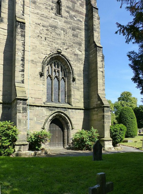
The main body of the nave is 14th century, at which point the present tower was also built. The two eastern bays of the arcades on both sides were added in 1854, replacing Saxon work. Saxon masonry survives between the arches and the clerestory. Saxon pillars removed from the nave at this point now stand in the south porch.
The tower and spire, rising to a height of 212 ft., are in Perpendicular style and according to the church guide were built in the 15th century. References to a build date of 1340 are considered to refer to the spire of the Priory church, not the parish church. The clerestory, nave roof and two-storey south porch are also of this period.
The windows show a variety of designs mainly from the 14th century, the most distinctive of which is in the chapel at the east end of the south aisle, which has lozenge and trefoil tracery under a flat head.
Significant internal fittings include a 14th century alabaster effigy of a knight, thought to be Sir Robert Frances of Foremark, a fine alabaster slab now in the south aisle to Gilbert Thacker (d.1563) and his unnamed wife, and a fine bust
in classical surround of Francis Thacker (d.1710). Over the south door is a royal coat of arms from the reign of George III, dated 1772 which used to hang over the chancel arch. The font, in Perpendicular style, is 19th century and there is a fine brass eagle lectern dated 1877.
Stained glass is 19th and 20th century with the possible exception of a small fragment in one of the north aisle windows.
The church is Listed Grade I.
 Map © Crown Copyright")
- Grid Square
- SK3027, 162 images (more nearby 🔍)
- Photographer
- Alan Murray-Rust (more nearby)
- Date Taken
- Sunday, 24 June, 2018 (more nearby)
- Submitted
- Tuesday, 26 June, 2018
- Subject Location
-
OSGB36:
 SK 3027 2716 [10m precision]
WGS84: 52:50.4663N 1:33.1233W - Camera Location
-
OSGB36: SK 3026 2716
- View Direction
- East-southeast (about 112 degrees)