2018
TQ3363 : Bollard in the Woods
taken 6 years ago, near to Sanderstead, Croydon, England
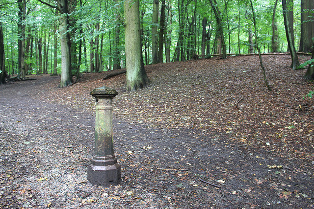
Bollard in the Woods
Beside the path along the northern edge of Croham Hurst is this unusual metal post.
I have no idea what it's for unless it's a parish boundary mark or something like that.
Any info welcome, and I'll edit the caption.
Updates:- 'I would think you are correct in your assumption that the bollard is a boundary post. The old series 25k OS, available as a pull down map on the left side of the Where's the Path website, shows a "BP" here on the civil parish boundary between Croydon to the west and Sanderstead to the east." Thanks, Nigel Cox.
And "Looking at Old Maps Link there are several marked in the area on 1:2,500 maps from 1897 onwards, running north and west from this point. They mark the County and Parliamentary Borough Boundaries." Thanks, Penny Mayes.
And "There are boundary markers in Croham Hurst, but not at the grid reference for this post. This 1:25" map shows the boundary line with some BP's marked. I think it's the boundary between Croydon County Borough and Addington parish. There's a boundary marker at TQ3380963507 Link (Archive Link ) ." Thanks, Mike Rayner
I have no idea what it's for unless it's a parish boundary mark or something like that.
Any info welcome, and I'll edit the caption.
Updates:- 'I would think you are correct in your assumption that the bollard is a boundary post. The old series 25k OS, available as a pull down map on the left side of the Where's the Path website, shows a "BP" here on the civil parish boundary between Croydon to the west and Sanderstead to the east." Thanks, Nigel Cox.
And "Looking at Old Maps Link
And "There are boundary markers in Croham Hurst, but not at the grid reference for this post. This 1:25" map shows the boundary line with some BP's marked. I think it's the boundary between Croydon County Borough and Addington parish. There's a boundary marker at TQ3380963507 Link
 Map © Crown Copyright")
TIP: Click the map for more Large scale mapping
- Grid Square
- TQ3363, 176 images (more nearby 🔍)
- Photographer
- Des Blenkinsopp (more nearby)
- Date Taken
- Thursday, 16 August, 2018 (more nearby)
- Submitted
- Wednesday, 19 September, 2018
- Subject Location
-
OSGB36:
 TQ 3385 6346 [10m precision]
WGS84: 51:21.2674N 0:4.7496W - Camera Location
-
OSGB36: TQ 3382 6347
- View Direction
- East-southeast (about 112 degrees)