2018
NH5893 : Bonar Bridge WWII defences (1)
taken 6 years ago, near to Culrain, Highland, Scotland
Bonar Bridge WWII defences (1)
-
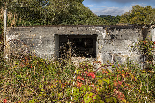
Pillbox (Type FW3/28): EDoB ID: e07740
This is the first of a series featuring photos of some of the more interesting and accessible pillbox defences around Bonar Bridge, and therefore it's by no means a comprehensive record of them all. This particular pillbox covered the undesignated road where it passes under a railway bridge, and where at one time there was also a roadblock. The photo shows the rear of the pillbox with its large open entrance doorway (through which a standard 2 pounder anti-tank gun could be wheeled through). Like others around Bonar Bridge this was subsequently modified to a standard machine gun position by bricking up the large front embrasure, and substituting a Turnbull MG mounting attached to the outside.
The type 28 pillbox was designed primarily as an anti-tank gun emplacement, typically for a standard 2 pounder, or a mounted 6 pounder Hotchkiss gun. Most of the type 28 pillboxes around Bonar Bridge differ in that they were subsequently downgraded by being converted instead to machine gun positions. It's not known why this was done, it may simply have been after a rethink on what exactly might have been the perceived threat. The conversion consisted of bricking up the large anti-tank gun embrasure to leave a smaller opening over which a Turnbull machine gun frame was attached. This was simply bolted onto the outside.
NH5893 : Bonar Bridge WWII defences (2)
 Map © Crown Copyright")
TIP: Click the map for more Large scale mapping
- Grid Square
- NH5893, 15 images (more nearby 🔍)
- Photographer
- Mike Searle (more nearby)
- Date Taken
- Sunday, 23 September, 2018 (more nearby)
- Submitted
- Sunday, 7 October, 2018
- Subject Location
-
OSGB36:
 NH 5808 9363 [10m precision]
WGS84: 57:54.5645N 4:23.8106W - Camera Location
-
OSGB36: NH 5808 9362
- View Direction
- Northwest (about 315 degrees)