2017
SO1091 : Frankwell Street
taken 7 years ago, near to Newtown/Y Drenewydd, Powys, Wales
This is 1 of 2 images, with title Frankwell Street in this square
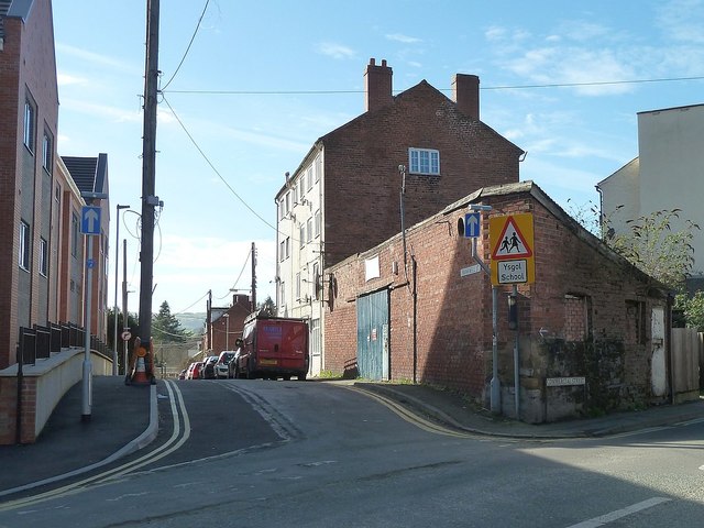
Frankwell Street
The little triangular building on the corner, right, is The Old Smithy and used to house the local cable relay company Wright's Radio Relay which switched off its service in April 2017. Probably one of the UK's earliest cable TV companies, it was launched in 1959 by local retailers who wanted to sell televisions in an area where receiving a TV signal was not possible for many houses because of the surrounding hills.
The four-storey building beyond it is The Barracks, built in the 1820s as part of the development of the Penygloddfa weaving district. The lower two floors provided back-to-back housing for six families, with weavers' workshops on the upper two floors. It acquired its name in about 1837 when it was occupied by the Army following the Chartist disturbances. The building has since become 1, 2 and 3 Hafren Cottages.
Info from Coflein: Link
The building on the left is part of the Llys Glan Yr Afon development.
See other images of Redevelopment of Severnside Yard, Newtown
Llys Glan-yr-Afon, Severnside Yard, Newtown
Severnside extra care scheme is a Wales & West Housing development built in partnership with Powys County Council in 2016 at a cost of £7.5m to provide accommodation for people with care and support needs.
It comprises 37 one bedroom and 11 two bedroom flats.
It was officially opened on 20 September 2017 although residents had moved in in summer 2016.
Planning application: Link
Information leaflet (pdf): Link
Wales & West Housing: Link
Hughes Architects website: Link
 Map © Crown Copyright")
TIP: Click the map for more Large scale mapping
- Grid Square
- SO1091, 876 images (more nearby 🔍)
- Photographer
- Penny Mayes (more nearby)
- Date Taken
- Thursday, 9 March, 2017 (more nearby)
- Submitted
- Sunday, 7 October, 2018
- Subject Location
-
OSGB36:
 SO 1086 9197 [10m precision]
WGS84: 52:31.0977N 3:18.9064W - Camera Location
-
OSGB36: SO 1089 9199
- View Direction
- West-southwest (about 247 degrees)
 although the cellar must have suffered.