2018
NZ6514 : Moor burning, Stanghow Moor
taken 6 years ago, near to Charltons, Redcar And Cleveland, England
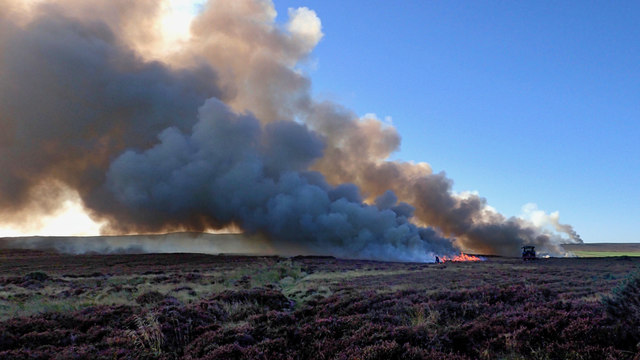
Moor burning, Stanghow Moor
The Farming Today program on BBC Radio 4 on Wednesday covered moorland management (its available Link as a podcast for 28 days). On it was a representative from the Moorland Association who said that rotational burning of grouse moorland had been voluntarily suspended. If you are not aware, rotational burning is the practice when our heather moorlands are deliberately set on fire in order to encourage fresh shoots of heather with the sole purpose of maximising the grouse population for shooting.
There is serious scientific evidence that burning such as this seriously degrades the protected habitats of our uplands by drying out the thick peat thereby increasing the risk of wildfires. Carbon, which has taken millennia to accumulate in the deep peat, is released into the atmosphere and the risk of flooding downstream is increased by making the moors less able to retain rain runoff. The European Commission recognised this as a serious degradation of our moorlands and launched an investigation. To avoid upsetting wealthy landowners the Environment Secretary Michael Gove came up with a cunning plan. Instead of banning or regulating moorland burning he dreamt up a scheme by which landowners signed up to a voluntary pledge to cease rotational burning.
It is evident that not all landowners intend to sign up to Mr Goves scheme. This is on Stanghow Moor today as seen from the A171 at Birk Brow. In the far distance are further fires which I believe are on Codhill Heights owned by Guisborough Estate. (A drone photo on the Guisborough FaceBook page confirms this.) Should the government continue to allow this practice of burning then it faces legal action by the European Commission. Until we actually leave the EU of course then we can do what we like.
For more info. refer to this RSPB press release Link
From my blog Link
 Map © Crown Copyright")
TIP: Click the map for more Large scale mapping
- Grid Square
- NZ6514, 30 images (more nearby 🔍)
- Photographer
- Mick Garratt (more nearby)
- Date Taken
- Thursday, 18 October, 2018 (more nearby)
- Submitted
- Monday, 22 October, 2018
- Subject Location
-
OSGB36:
 NZ 6579 1471 [10m precision]
WGS84: 54:31.4050N 0:59.1038W - Camera Location
-
OSGB36: NZ 6590 1478
- View Direction
- West-southwest (about 247 degrees)