2018
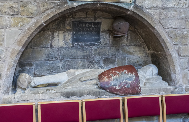
SK7519 : Crusader effigy, St Mary's church, Melton Mowbray
taken 6 years ago, near to Melton Mowbray, Leicestershire, England
Crusader effigy, St Mary's church, Melton Mowbray
Effigy of a Crusader, probably the (later) Hamo Belers, not the brother of Roger de Mowbray as stated>. Circa 1303.
St Mary's church, Melton Mowbray
Grade I listed.
A large cruciform church dating from the twelfth century, although little of this fabric is visible. The oldest part of the church is the base of the tower.
The church consists of nave with north and south aisles and clerestory which extends into the transepts, central tower with north and south transepts (unusually, these are aisled), chancel, west porch, and vestry.
The tower is of three stages, the upper part dates from around 1500 and is topped with eight pinnacles and spirelet. There are 10 bells.
Pevsner dates the bulk of the church to between 1280 and 1330. The nave is older than the chancel, and has six-bay arcades. The north transept dates from around 1330, with the south transept a little earlier. The transepts both have three-bayed aisles. The clerestory windows were added around 1500, and are all clear glazed. There are 48 in total.
The west porch dates from the early fourteenth century.
There are numerous stained-glass windows and several monuments including the tomb of Lord Mowbray.
The church was restored in the nineteenth century by Gilbert Scott, and has recently also undergone a major restoration including renewing the floor, lighting, organ, and the addition of toilets and kitchen.
This page has been
viewed about
110 times
 Map © Crown Copyright")
 SK 7527 1902 [10m precision]