NS3975 : Remains of Ballantine's Distillery
taken 19 years ago, near to Dumbarton, West Dunbartonshire, Scotland
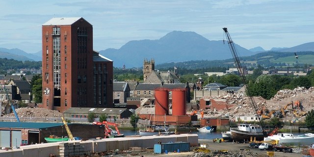
Ben Lomond (NN3602) dominates the skyline. The buildings in the foreground, on the near side of the River Leven, are on Sandpoint.
The tower near the centre of the picture is that of NS3975 : The Old Burgh Hall. Much further away, visible in the gap between the Old Burgh Hall and the large brick tower, is the top of NS3880 : The former Argyll Motor Works.
The view is from NS3974 : Dumbarton Rock: Bower Battery; compare the equivalent view from there in 2013: NS3975 : Remains of Ballantine's distillery.
The distillery was built for Hiram Walker & Sons (Scotland), on the site of the shipyard of Archibald McMillan & Son. That shipyard became derelict after being acquired by Shipbuilding Securities, Ltd. Railway tracks Link that had once linked the shipyard to a goods yard continued to serve the distillery; as of 2017, parts of those tracks remain visible on Castle Street and in an adjacent car park.
The grain distillery, which was said to be the largest in Europe, was officially opened on Wednesday the 28th of September 1938 by Lord (George) Nigel Douglas Hamilton, Commissioner for Special Areas in Scotland. This was the day after the liner Queen Elizabeth had been launched from John Brown's shipyard at Clydebank; that event would overshadow, to some extent, the opening of the distillery, but it would also provide some points of comparison, which were made during the building's opening ceremony. For example, the distillery was constructed on about 2500 piles, each of which supported a weight of about 30 tons; the total weight of the building was therefore about 75,000 tons, which, as pointed out on the day, was about the same as the total dead weight of the "Queen Elizabeth".
Construction had taken about a year. The building contained about 2 million bricks, 10,000 cubic yards of reinforced concrete, and 3,000 tons of steel. The boiler could generate about 1000 horse-power, as well as evaporating 50,000 lbs of water per hour. The total storage capacity of the tanks in the building was about 1 million gallons. The first warehouse constructed had a capacity of 1,700,000 gallons, a taxable content of about £6,800,000. As was pointed out on the day of opening, the excise duty on that quantity of spirits would be about sufficient to pay for a battleship.
According to the book "The Ballantine's Story" (cited below), the bricks were red Accrington-tile, and preparations for war had been given priority over construction on the site, delaying the completion of the building work.
The opening ceremony itself was to have been held in Dumbarton's Burgh Hall, but that building had been commandeered at the last minute for what were tersely described as "air raid precaution purposes" (what had happened was that the Town Council's A.R.P. Subcommittee had decided, at a meeting held at 9pm on Monday the 26th, that there was an urgent need for them to take over the arrangements for supplying civilian gas masks; they therefore sent, at 3:30 on Tuesday morning, a fleet of motor lorries to the national gas mask supply centre in Galashiels; when the lorries returned with the packaged parts, at 5:30 on the evening of Tuesday the 27th, almost 100 volunteers set to work separating these parts and assembling the respirators; they did so on tables set out for that purpose in the Burgh Hall, and that work was still going on, with additional volunteers, when the distillery opened on Wednesday the 28th). At short notice, sufficient space was found for the opening ceremony in a large storage building in the distillery complex itself. Harry C Hatch, Chairman of the firm, presided and welcomed the guests, Lord Nigel Douglas Hamilton performed the opening ceremony, and Provost James Campbell represented Dumbarton Town Council.
The original Hiram Walker company had been founded by a man of that name in Ontario in 1858, and it remained in his family until it was acquired by Harry C Hatch and his business associates in December 1926; they took charge in January 1927. More or less the same group of business interests had already acquired the distillery firm of Gooderham & Worts, Ltd, Ontario, in 1923. That firm had been founded in 1832, and it was said to be the oldest distillery in Canada. The two firms merged in 1927, and, in 1930, the combined company acquired a 60 percent stake in the Stirling Bonding Company, and J & G Stoddard, Blenders and Exporters. In 1936, George Ballantine & Son was added to their blending interests. In 1933, with the impending repeal of Prohibition in the United States, the company had decided to entered the market there in a big way: at Peoria, Illinois, the company had built what Hatch claimed was "the largest and most modern distillery in the whole world".
Hatch also explained, in his speech during the opening ceremony, that it was the demand for Scotch Whisky in the United States that had made the building of a distillery at Dumbarton a tempting and practical venture. He drew a distinction between those distilleries that blend whisky, and those that produce only the basic grain whisky with which the malts are blended; he then noted a perceived scarcity of grain whisky in Scotland. The product of the Dumbarton plant would be made available to those blenders who cared to use it.
Almost all of the material used to construct the buildings was from Britain: the exceptions included parts of the grain conveying plant, which could not be obtained in this country, as well as the reinforcing bars and about 60 tons of plate steel, which were purchased abroad because the British steel industry was unable to supply them (presumably because priority was given to preparations for war).
At the time of the official opening, war preparations were very much on people's minds: the last-minute change of venue caused by the urgent assembling of gas mask respirators has already been mentioned. Around the same time, trenches would be dug in nearby Levengrove Park, in the Cunningham Graham Memorial Park, and elsewhere; these trenches would then be covered over to provide bomb shelters. The speeches made during the official opening alluded to the worrying situation in Europe, and it was stated that the building and its machinery would be made available for war purposes, should the need arise. On a more positive note, it was pointed out that the recent opening of an Aircraft Factory, coupled with the opening of this distillery, had added some diversity to the industries in Dumbarton; this diversity would benefit the town, especially if any one of those industries later went into decline. (The reference made there was to the Blackburn Aircraft Factory, which was near Dumbarton Rock; construction of that factory began in 1937; the site was later occupied by Allied Distillers, and, still later, by housing, built in 20162017).
Subsequent developments at the distillery down to about 1990 are described in the book "The Ballantine's Story", cited below; the book also discusses the blending plant that was later built at Kilmalid (NS39767750), and it details the corporate mergers and restructuring that took place throughout the decades, as well as the changing fortunes of the whisky industry in Scotland.
See Link for more on the Kilmalid bottling and blending plant.
Most of the distillery complex here in Dumbarton had been demolished by 2007, but a single tall brick tower remained long afterwards; its demolition was delayed when a planned housing development stalled. The remaining tower was viewed by many as an eyesore; also, on more than one occasion, newspaper accounts appeared about children who had entered the building and who were spotted in precarious positions on the upper floors. However, work on the site eventually resumed: by January 2017, that last brick tower was being torn down, briefly exposing to view the reinforcing steel girders within the structure.
A housing development, by Cullross Ltd and Dunbritton Housing, was planned for the site: a "mixed use development comprising 196 flats and terraced houses"; the proposed development also includes offices, and a riverside path that would lead from Riverside Lane (behind the shops on the High Street) to Castle Road.
References:
▪ "The Lennox Herald" (newspaper): issue of 1st October 1938, for details of the building and for an account of the opening ceremony and speeches.
▪ "The Glasgow Herald" (newspaper): page 7 of the edition for Thursday 29th September 1938. The coverage there is less detailed than in the Lennox Herald article just cited, but it is accessible online: Link
▪ "The Ballantine's Story" (book by Jonathan Mantle, 1991): this includes later developments, down to the time of writing.
 Map © Crown Copyright")
- Grid Square
- NS3975, 671 images (more nearby 🔍)
- Photographer
- Lairich Rig (more nearby)
- Date Taken
- Monday, 8 August, 2005 (more nearby)
- Submitted
- Friday, 7 December, 2018
- Subject Location
-
OSGB36:
 NS 3974 7512 [10m precision]
WGS84: 55:56.5395N 4:34.0557W - Camera Location
-
OSGB36: NS 3987 7449
- View Direction
- North-northwest (about 337 degrees)