TQ3080 : Labyrinth, Embankment Underground Station
taken 6 years ago, near to London, The City of London, England
Embankment is a London Underground station. It is served by the Circle, District, Northern and Bakerloo lines. On the Northern and Bakerloo lines, the station is between Waterloo and Charing Cross stations; on the Circle and District lines, it is between Westminster and Temple and is in Travelcard Zone 1.
The station is in two parts: sub-surface platforms opened in 1870 by the Metropolitan District Railway (MDR) as part of the company's extension of the Inner Circle eastwards from Westminster to Blackfriars and deep-level platforms opened in 1906 by the Baker Street and Waterloo Railway (BS&WR) and 1914 by the Charing Cross, Euston and Hampstead Railway (CCE&HR). A variety of underground and mainline services have operated over the sub-surface tracks and the CCE&HR part of the station was reconstructed in the 1920s
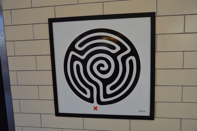
Mark Wallinger, one of the UKs leading contemporary artists, has created a major new artwork for London Underground to celebrate its 150th anniversary. The result, commissioned by Art on the Underground, is a multi-part work on a huge scale that will be installed in every one of the Tubes 270 stations.
 Map © Crown Copyright")
- Grid Square
- TQ3080, 6977 images (more nearby 🔍)
- Photographer
- N Chadwick (more nearby)
- Date Taken
- Wednesday, 8 August, 2018 (more nearby)
- Submitted
- Thursday, 13 December, 2018
- Subject Location
-
OSGB36:
 TQ 3040 8037 [10m precision]
WGS84: 51:30.4334N 0:7.3474W - Camera Location
-
OSGB36: TQ 3040 8037
- View Direction
- North-northeast (about 22 degrees)