SX9372 : The Salty
taken 6 years ago, near to Shaldon, Devon, England
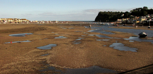
The Salty is a bank of sand and shingle at the mouth of the River Teign. It extends from Shaldon on the south shore out into the estuary. The river swings round its north and east sides in a great bend, forming Teignmouth harbour, before turning sharply east again to meet the sea between the Point and the Ness.
At low tide the Salty forms a great expanse of grey-brown in views across the harbour. At high tide it is completely covered by water. A Teign ferryman recalled that 30 years ago (c. 1981) it was never submerged: it had grass growing on it. People camped there in the summer. Grace Griffiths History of Teignmouth (2001 edition) remarks that a crossing by boat may always have existed from Teignmouth In the early seventeenth century the crossing was within the Manor of West Teignmouth and therefore further up the river than the present one. Salty the large sandy island in the middle of the Teign was then much lower if it existed at all.
The Salty may be safely explored dryshod for an hour or two either side of low tide; anglers wear waders and stay longer. It can be reached by boat, or on foot from the south end of the Teignmouth and Shaldon Bridge or from floodgate No.2 west of the playing field in Shaldon. People have been seen on horseback. It is a peaceful place with unique views and an interestingly varied surface.
The bridge, which crosses the western side of the Salty, was built of steel and concrete between 1927 and 1931. Its predecessors were timber bridges; the first, opened in 1827, was the longest timber bridge in England at the time. After partial collapse in 1838 it was rebuilt, reopening in 1840 but it too partially collapsed in 1893. The present bridge was strengthened and the footways widened between 1998 and 2002. Additional slender steel supports were placed alongside the original steel piers. The sound of the pile-driver echoed around the harbour for many a month.
The Salty occupies a large part of the photogenic SX9372 gridsquare. It appears in many photographs taken from the two waterfronts, the bridge and other viewpoints. Some photos of the harbour are wrongly titled The Salty because they were taken when it was covered by the tide.
 Map © Crown Copyright")
- Grid Square
- SX9372, 1928 images (more nearby 🔍)
- Photographer
- Derek Harper (more nearby)
- Date Taken
- Friday, 28 September, 2018 (more nearby)
- Submitted
- Sunday, 16 December, 2018
- Subject Location
-
OSGB36:
 SX 933 725 [100m precision]
WGS84: 50:32.5502N 3:30.4313W - Camera Location
-
OSGB36: SX 9310 7266
- View Direction
- East-southeast (about 112 degrees)