2019
TR3140 : View from the Dover Sea Sports Centre
taken 5 years ago, near to Dover, Kent, England
This is 1 of 68 images, with title View from the Dover Sea Sports Centre in this square
View from the Dover Sea Sports Centre
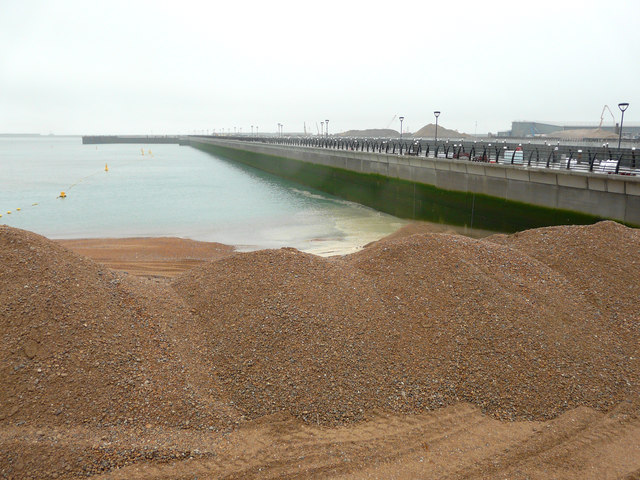
Out in the harbour, the marina curve appears to have been completed and now permanent railings have been installed to this side of the pier. Beyond it work is now being undertaken to construct a pier. Just below the sports centre, there is a pile of shingle, which was being cleared from the piles of the new marina pier so that anodes can be fitted to fitted to reduce corrosion of the piles. The temporary rock barrier has also been removed. The beach will be restored to its previous profile when the work is completed, aided by the natural build-up of shingle.
This TR3140 : View from the Dover Sea Sports Centre was taken a week ago.
Planning permission was granted by Dover District Council under application number DOV/15/01254 for the reduction of ramps to either end of sheet pile section and construction of cargo berths and marina curve, to be attached to masonry section. The ramps, which the planning application refers to, formed part of the Prince of Wales Pier.
Further images of the marina curve (also known as promenade pier) may be viewed on Link while the pier beyond it is referred to as a pierhead on the website. Search for beach shingle for the text referring to the work that is being carried out.
This TR3140 : View from the Dover Sea Sports Centre was taken a week ago.
Planning permission was granted by Dover District Council under application number DOV/15/01254 for the reduction of ramps to either end of sheet pile section and construction of cargo berths and marina curve, to be attached to masonry section. The ramps, which the planning application refers to, formed part of the Prince of Wales Pier.
Further images of the marina curve (also known as promenade pier) may be viewed on Link
 Map © Crown Copyright")
TIP: Click the map for more Large scale mapping
- Grid Square
- TR3140, 785 images (more nearby 🔍)
- Photographer
- John Baker (more nearby)
- Date Taken
- Friday, 25 January, 2019 (more nearby)
- Submitted
- Sunday, 3 February, 2019
- Subject Location
-
OSGB36:
 TR 3199 4087 [10m precision]
WGS84: 51:7.2072N 1:18.8168E - Camera Location
-
OSGB36: TR 3197 4087
- View Direction
- East-southeast (about 112 degrees)