TQ6404 : Pevensey Castle
taken 5 years ago, near to Westham, East Sussex, England
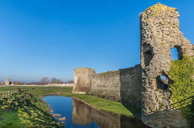
Pevensey Castle is a mediaeval castle surrounded by substantial Roman walls that remain from the time when a Saxon Shore Fort was situated here.
The Roman fort was known as Anderita and was one of a number that guarded the south-eastern coast of the Roman province in Britain against raids from pagans, such as the Saxons, that were prevalent in the 3rd Century AD. The walls remain impressively intact to a height of up to 27' (24m) for 2/3 of the circuit of the castle grounds, despite being 1,700 years old and having been twice abandoned. Anderita was the last Saxon Shore fort to be built in England and along with Portchester much further to the west, is one of the best surviving examples.
Between Roman and Norman times the fort was pretty-much abandoned, but the intact state of the Roman curtain walls, suggests that it was considered important enough a stronghold not to be dismantled and its stones used for building - a fate which befell most Roman structures during the "Dark Ages" (c.415AD - 800AD)
Pevensey was the landing place for William the Conqueror's invasion fleet, and shortly before his arrival Harold's army had been camped here awaiting his unwelcome arrival. However, the challenge from Harald Hardrada of Norway allied with Harold's own brother Tostig meant that Harold had to abandon the south and march his army northwards to defeat these northern enemies. This left Pevensey undefended when William finally managed to cross the Channel, having been severely delayed by storms and winds blowing from the wrong direction.
Knowing Pevensey's strategic importance, William ordered the construction of a castle here within the existing Roman defences soon after defeating the English a few miles away at Battle near Hastings.
So the origins of the mediaeval castle date back to Norman times, but little of the C11th construction remains as the castle was enlarged and altered almost continually for the next 300 years.
Most of what is now seen, including the moat, the main walls, buttresses and towers, date from the C13th, although the remains of the massive keep within the inner castle defences is somewhat older.
After the mediaeval period it was once again abandoned and from the C16th onwards it gradually decayed and collapsed in many places. Much of the stone of the mediaeval castle was plundered, but interestingly, once again, the Roman walls largely survived these depredations.
Finally, the castle had one more dramatic lease of life, when it was garrisoned during WWII and several "pill boxes" were built into its structure, made of stone like the castle, to blend into the ancient structure both as camouflage and to maintain the fabric of the ancient monument.
The castle is now in the care of English Heritage Link
EH Ancient Monument listing here Link
 Map © Crown Copyright")
- Grid Square
- TQ6404, 504 images (more nearby 🔍)
- Photographer
- Ian Capper (more nearby)
- Date Taken
- Friday, 15 February, 2019 (more nearby)
- Submitted
- Saturday, 16 February, 2019
- Subject Location
-
OSGB36:
 TQ 644 048 [100m precision]
WGS84: 50:49.1708N 0:20.0234E - Camera Location
-
OSGB36: TQ 644 047
- View Direction
- North-northeast (about 22 degrees)