2019
NS3779 : Carman Hill-fort: eastern edge
taken 5 years ago, near to Alexandria, West Dunbartonshire, Scotland
Carman Hill-fort: eastern edge
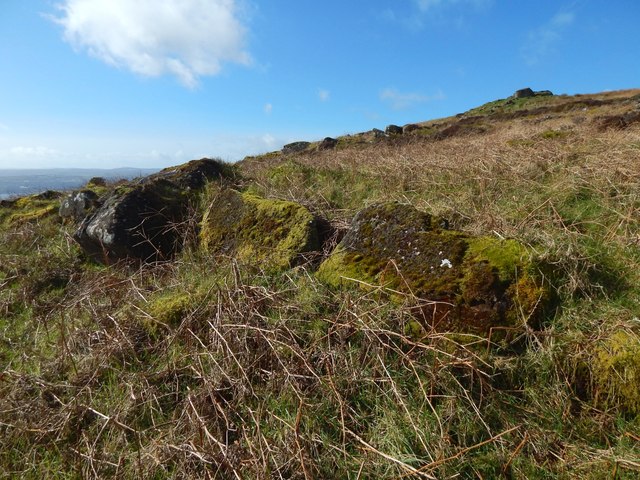
The picture was taken from just outside the eastern side of the fort, and it shows what is perhaps the best surviving section, albeit a short one, of its outer boundary wall.
Specifically, what is in the foreground is part of the outer wall of the annexe (there was a double wall here on the eastern side, the space between the two walls forming a kind of annexe to the fort).
Another wall, parallel to this one, can be seen about 20 metres behind it; that is the inner wall of the annexe. Behind that, in turn, is the main body of the area that lies within the outer enclosure of the fort.
In the right background, further up the slope, is the most prominent of several groups of boulders that can be seen near the summit of the hill; that group lies within the fort's outer enclosure, but not its inner enclosure, which is a little further up the hill.
Carman Hill-fort
This large hill-fort see Link
(at Canmore) was identified in 1954 from aerial photographs, and is thought to date from the Early Historic period (Dark Ages). See Link for a Geograph article on the fort. See Link
 Map © Crown Copyright")
TIP: Click the map for more Large scale mapping
- Grid Square
- NS3779, 116 images (more nearby 🔍)
- Photographer
- Lairich Rig (more nearby)
- Date Taken
- Monday, 11 March, 2019 (more nearby)
- Submitted
- Sunday, 24 March, 2019
- Subject Location
-
OSGB36:
 NS 3726 7940 [10m precision]
WGS84: 55:58.7944N 4:36.5906W - Camera Location
-
OSGB36: NS 3729 7940
- View Direction
- WEST (about 270 degrees)