TG2236 : Interior, St Mary's church, Roughton
taken 5 years ago, near to Roughton, Norfolk, England
Records of the church dates back to the Domesday book, and is there are also nearby tumuli showing activity before the arrival of the Danes.
The church is remote from the village, which probably moved after the black death of 1349.
The church is notable for its round tower which is the oldest part of the building. It is built in Norfolk brownstone with a herringbone pattern near the base and small circular windows to the north and south. It is dated to Saxo-Noman times. These windows were probably filled in in the fourteenth century. The brick parapet is from later on and there was once possibly a steeple as well.
There are also traces of Saxon work in the west wall, and Pevsner reports a small door behind the new organ.
There was also once a chantry chapel on the north side of chancel, the remains can still be seen in the wall.
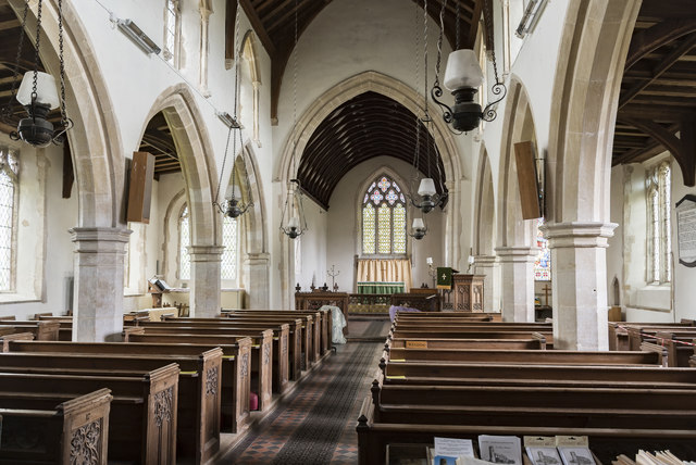
The chancel was rebuilt in the fourteenth century when the aisles were also added along with the chantry chapel and porches. The chancel has the usual sedilia and piscina.
The nave has four bay arcades with octagonal piers There are clerestory windows above. These feature shafts and fillets which rest on grotesques. Most of the woodwork including the roof is from the nineteenth century.
There is an octagonal font from the fourteenth century.
The tower has three bells.
The organ is on the west wall, and appears to be new.
 Map © Crown Copyright")
- Grid Square
- TG2236, 86 images (more nearby 🔍)
- Photographer
- Julian P Guffogg (more nearby)
- Date Taken
- Wednesday, 22 May, 2019 (more nearby)
- Submitted
- Tuesday, 28 May, 2019
- Subject Location
-
OSGB36:
 TG 2203 3652 [10m precision]
WGS84: 52:52.8173N 1:17.8959E