2019
ND3971 : Stacks of Duncansby
taken 5 years ago, near to John o' Groats, Highland, Scotland
This is 1 of 3 images, with title Stacks of Duncansby in this square
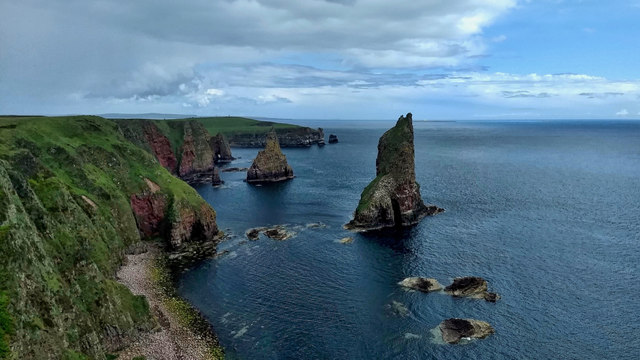
Stacks of Duncansby
A pair of dramatic sea stacks just off the north-easterly tip of the British mainland. But we almost lost them. Apparently in 1953, in what seems like a bizarre Monty Python sketch scientists from the Aldermaston Atomic Weapons Establishment had proposed to test a nuclear bomb on top of one of the stacks. The Stacks of Duncansby was suggested because there were not many people living up here. The usual testing at this time would have been on top of a tower, about 150-200 feet off the ground. The bomb would have been the size of a kitchen freezer and set on top of the tallest of the Stacks. It would have been comparable to the atom bomb dropped by the US on Hiroshima in August 1945, equivalent to 16,000 tons of TNT. The nuclear fall out would have been devastating but in the end, it was the Scottish weather that defeated the project. It was too wet for the electronics. The nuclear scientists then proposed to Donna Nook in Lincolnshire, then Skipsea, between Bridlington and Hull, but finally, a UK test site was abandoned and it was eventually carried out at Emu Field, in South Australia.
From my photo-diary for 20 June 2019 see Link
From my photo-diary for 20 June 2019 see Link
 Map © Crown Copyright")
TIP: Click the map for more Large scale mapping
- Grid Square
- ND3971, 15 images (more nearby 🔍)
- Photographer
- Mick Garratt (more nearby)
- Date Taken
- Thursday, 20 June, 2019 (more nearby)
- Submitted
- Thursday, 20 June, 2019
- Subject Location
-
OSGB36:
 ND 3999 7187 [10m precision]
WGS84: 58:37.8337N 3:2.1108W - Camera Location
-
OSGB36: ND 39752 71607
- View Direction
- Northeast (about 45 degrees)