Geograph - photograph every grid square
2019
SH1626
: Porth Simdde
taken
5 years ago
,
near
to
Aberdaron
, Gwynedd, Wales
This is 1 of
8 images, with title Porth Simdde
in this square
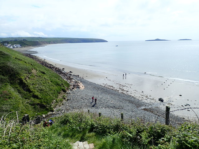
Porth Simdde
Porth Simdde is for the outflow of Afon Saint, down a steep gully. The Wales Coast Path descends steeply from the Aberdaron side and then another steep stepped ascent on the other side.
© Copyright
Eirian Evans
and licensed for
reuse
under this
Creative Commons Licence
.
Licensing
Download
More Sizes
Share...
Share this photo via Twitter
Share this photo via Facebook
Share this photo via Pinterest
Share this photo via Flipboard
Share this photo via email/e-card
Grab a Stamped/Watermarked Image
Mark
👍🏻
Like Image
👍🏻
Like Description
Update Information
Contact Contributor
Geographical Context:
Coastal
Paths
Sport, Leisure
Estuary, Marine
Primary Subject:
Cove
This photo is linked from:
Automatic Clusters
: ·
Path at Porth Simdde [9]
Title Clusters
: ·
Porth Simdde [8]
·
TIP: Click the map for more Large scale mapping
Grid Square
SH1626
, 88 images (
more nearby
🔍
)
Photographer
Eirian Evans
(
more nearby
)
Date Taken
Saturday, 18 May, 2019 (
more nearby
)
Submitted
Saturday, 10 August, 2019
Subject Location
OSGB36:
SH 167 263
[100m precision]
WGS84:
52:48.2092N
4:43.2021W
Camera Location
OSGB36:
SH 167 263
View Direction
East-southeast (about 112 degrees)
NW
N
NE
W
Go
E
SW
S
SE
Discuss SH1626
View this location on ...
Geograph Coverage Map (includes OSM etc)
Geograph Links Page
Open in Google Maps
Navigate to location with Google Maps
Open in Google Earth Pro
Open in Google Earth for Web
Open in Bing Maps
Navigate with Google Maps
Lookup nearest Postcode
Image Type
(about)
:
geograph
This page has been
viewed
about
34
times
☰
Home
View
Search
Marked Images
Maps
Browser
Explore
Showcase
New Images
Collections
Interact
Games
Discussions
Blog
Contributors
Submit
Statistics
Leaderboards
General
FAQ
Help Pages
Sitemap
Contact Us
Support Us
sponsored by
🔍
What to search:
Photos
Enter keywords or a location/postcode to search nearby images
Photos near SH1626
Enter a Grid Reference
Placenames
Collections
Website Pages
Everything
Others:
Advanced Search
|
Image Browser
Or:
Coverage Map
|
Searchable Map
You are not logged in
login
|
register