2019
NZ9203 : Ramsdale Stone Circle
taken 5 years ago, near to Raw, North Yorkshire, England
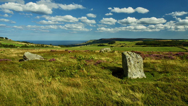
Ramsdale Stone Circle
How many stones make a stone circle? These three standing stones on the appropriately named Standing Stones Rigg on Fylingdales Moor are known as the Ramsdale Stone Circle. Ramsdale being the name of a hamlet and a beck that eventually flows into the North Sea at Boggle Hole. It is not known if there were originally any more stones in the circle which have disappeared over time. One explanation is that they were part of a kerb around a burial cairn which itself has disappeared. All speculation. What is known is that there is plenty of evidence Bronze Age activity on Standing Stones Rigg including bowl barrows and linear earthworks.
From my photo-diary for 23rd August 2019 see Link
From my photo-diary for 23rd August 2019 see Link
 Map © Crown Copyright")
TIP: Click the map for more Large scale mapping
- Grid Square
- NZ9203, 17 images (more nearby 🔍)
- Photographer
- Mick Garratt (more nearby)
- Date Taken
- Friday, 23 August, 2019 (more nearby)
- Submitted
- Friday, 23 August, 2019
- Subject Location
-
OSGB36:
 NZ 9204 0377 [10m precision]
WGS84: 54:25.2629N 0:34.9813W - Camera Location
-
OSGB36: NZ 9204 0377
- View Direction
- EAST (about 90 degrees)