2018
SP8841 : M1 at Driver Location A81.4
taken 5 years ago, near to Willen, Milton Keynes, England
M1 at Driver Location A81.4
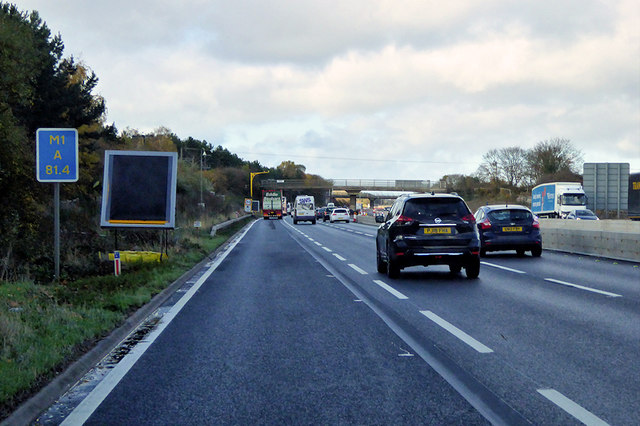
Passing Driver Location Sign (DLS) at M1 A81.4, near to Milton Keynes.
Driver location signs are now widely used across the motorway and Aroad network. First introduced in 2003, they complement distance marker posts. Both types of marker post display the distances in kilometres from a nominal start point but driver location signs are designed to be read by motorists or their passengers when, for instance, they need to pass details to the emergency services. They give the same location information as distance marker posts, but more visibly on larger signs. They are normally spaced at 500-metre intervals along the nearside verge but if obstacles (eg sliproads or bridges) prevent signs from being erected at these locations, then the interval is reduced to either 400 or 300 metres.
Driver location signs have three pieces of information:
The road identifier (eg M1)
The carriageway identifier The letter on the second line of the signs, usually A or B, tells the emergency services or the Highways Agency in which direction you are travelling. The letter A ("Away from London") normally denotes carriageways leaving London (or clockwise in the case of the M25) and "B" ("Back to London") is used for carriageways going to London (anticlockwise on the M25).
The location (which is identical to the location given on marker posts). Distances are accurate to within 20 metres and are generally quoted from the beginning of the motorway.
So in this case, we are travelling on the M1, away from London, and are 81.4km from the start of the motorway.
Link (Archive Link ) DFT Interim Advice Note (December 2010)
Link The AA
Link SABRE
Driver location signs are now widely used across the motorway and Aroad network. First introduced in 2003, they complement distance marker posts. Both types of marker post display the distances in kilometres from a nominal start point but driver location signs are designed to be read by motorists or their passengers when, for instance, they need to pass details to the emergency services. They give the same location information as distance marker posts, but more visibly on larger signs. They are normally spaced at 500-metre intervals along the nearside verge but if obstacles (eg sliproads or bridges) prevent signs from being erected at these locations, then the interval is reduced to either 400 or 300 metres.
Driver location signs have three pieces of information:
The road identifier (eg M1)
The carriageway identifier The letter on the second line of the signs, usually A or B, tells the emergency services or the Highways Agency in which direction you are travelling. The letter A ("Away from London") normally denotes carriageways leaving London (or clockwise in the case of the M25) and "B" ("Back to London") is used for carriageways going to London (anticlockwise on the M25).
The location (which is identical to the location given on marker posts). Distances are accurate to within 20 metres and are generally quoted from the beginning of the motorway.
So in this case, we are travelling on the M1, away from London, and are 81.4km from the start of the motorway.
Link
Link
Link
M1 Motorway
The M1 is a northsouth motorway connecting London to Leeds, where it joins the A1(M) near Aberford. It was the first motorway to be completed in the United Kingdom.
The motorway is 193 miles long and was constructed in four phases. Most of the motorway was opened between 1959 and 1968 but the southern end was extended in 1977 and the northern end was extended in 1999.
 Map © Crown Copyright")
TIP: Click the map for more Large scale mapping
- Grid Square
- SP8841, 16 images (more nearby 🔍)
- Photographer
- David Dixon (more nearby)
- Date Taken
- Sunday, 11 November, 2018 (more nearby)
- Submitted
- Tuesday, 10 September, 2019
- Subject Location
-
OSGB36:
 SP 883 414 [100m precision]
WGS84: 52:3.8529N 0:42.7839W - Camera Location
-
OSGB36: SP 883 413
- View Direction
- Northwest (about 315 degrees)