2018
SP7257 : Footbridge over the M1 at Northampton Services
taken 5 years ago, near to Rothersthorpe, West Northamptonshire, England
This is 1 of 2 images, with title Footbridge over the M1 at Northampton Services in this square
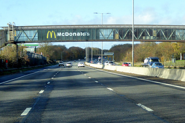
Footbridge over the M1 at Northampton Services
The services are about 4 miles south of Northampton town centre, at the Rothersthorpe Interchange (M1/A43). When opened in 1978, the service area was named "Rothersthorpe" and was located between junctions 15 and 16. However, in 1991 the Blisworth Bypass on the A43 was opened, this linked into the M1 at the Rothersthorpe site, creating a new junction (15A) surrounding the service area.
The footbridge was taken out of use in 2002 when the site was redeveloped, though it still remains in place.
The footbridge was taken out of use in 2002 when the site was redeveloped, though it still remains in place.
M1 Motorway
The M1 is a northsouth motorway connecting London to Leeds, where it joins the A1(M) near Aberford. It was the first motorway to be completed in the United Kingdom.
The motorway is 193 miles long and was constructed in four phases. Most of the motorway was opened between 1959 and 1968 but the southern end was extended in 1977 and the northern end was extended in 1999.
 Map © Crown Copyright")
TIP: Click the map for more Large scale mapping
- Grid Square
- SP7257, 98 images (more nearby 🔍)
- Photographer
- David Dixon (more nearby)
- Date Taken
- Sunday, 11 November, 2018 (more nearby)
- Submitted
- Wednesday, 11 September, 2019
- Subject Location
-
OSGB36:
 SP 722 573 [100m precision]
WGS84: 52:12.5625N 0:56.6438W - Camera Location
-
OSGB36: SP 723 572
- View Direction
- West-northwest (about 292 degrees)