TL3759 : First sight of the A428 footbridge from the path to Dry Drayton
taken 5 years ago, near to Hardwick, Cambridgeshire, England
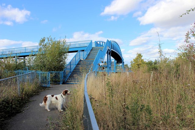
This 1.5 mile footpath forms part of the 273 mile Greenwich Meridian Trail & is more or less at its midway point. It actually lies about a mile to the east of the Meridian. The path starts on St Neot's Road in Hardwick, crosses the adjacent A428 dual-carriage way on an imposing structure opened in 2007 which theoretically allows those in wheelchairs to use the path. It follows the Callow Brook on its east side for about a mile, then crosses over it on a wooden bridge, before following the edge of a field to a gateway at the rear of Dry Drayton churchyard. The path passes through the churchyard to end at the village green.
This is an ancient footpath - it is shown in a map of Dry Drayton dated 900AD although its route now is slightly different from that shown. In particular, over the past 15 years or so it has been diverted twice: the path used to start on St Neots Road about 400 yards to the east. There was no bridge - crossing the A428 required one to take ones life in one's hands & I guess not many risked it. The path followed field edges for most of the way rather than the Brook & made a 90 deg turn downhill to meet the Brook about 400 yards from the wooden bridge. The other diversion was at Dry Drayton: after crossing Callow Brook the path headed directly to the churchyard gateway across the field which required a strip to be mown in the crop. This previous route is described in the Dry Drayton Footpath booklet ( Link) where it is listed as Footpath 17.
Inaugurated in 2009, the 273 mile long route follows the line of the Prime Meridian as closely as practical, using public rights of way. The route does not slavishly stick to The Meridian, but has been chosen to give an interesting, varied and memorable walk.
From the Meridian Monument in Peacehaven, the route goes over the South Downs, across the Weald, through Ashdown Forest and across the North Downs. In London, too much street walking has been avoided by the judicious use of woods, commons, parks; the excellent Green Chain Walk and the Pool and Ravenbourne Rivers as a way of reaching Greenwich. The Greenwich Foot Tunnel takes the trail north of the river where the Thames Path and Limehouse Cut lead to Stratford and then to Epping Forest, a green way out of London. From Waltham Abbey, the route follows the Lea Valley to Stanstead Abbotts, continues across the hills of Hertfordshire into Cambridgeshire and the halfway point at the village of Hardwick. A loop to Cambridge, through Grantchester, is provided as an option.
The third part of the route crosses The Fens, passes through March to reach Holbeach and then historic Boston. The final part traverses the lovely Lincolnshire Wolds to Louth and then reaches Cleethorpes on the south shore of the Humber Estuary. The trail restarts at the Meridian Marker near Patrington. From there it skirts Withernsea and reaches the end at Sand le Mere where the Meridian crosses the fastest eroding coastline in England.
The route uses GMT as a logo TQ3940 : Greenwich Meridian Trail Logo.
 Map © Crown Copyright")
- Grid Square
- TL3759, 63 images (more nearby 🔍)
- Photographer
- Martin Tester (more nearby)
- Date Taken
- Thursday, 12 September, 2019 (more nearby)
- Submitted
- Tuesday, 24 September, 2019
- Subject Location
-
OSGB36:
 TL 3727 5973 [10m precision]
WGS84: 52:13.1211N 0:0.4786E - Camera Location
-
OSGB36: TL 3726 5971
- View Direction
- North-northeast (about 22 degrees)