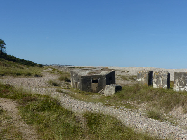
NJ2867 : Pillbox (PSG:e02461), Type FW3/24
taken 5 years ago, 3 km from Lochhill, Moray, Scotland
The anti-invasion defences are of sufficient extent and historical importance that they are classified as a Scheduled Monument. They form the 'Right Sector' of the 'Defence Sector' along the Moray coast.
The primary element is a series of pillboxes linked by lines of anti-tank blocks which extend over a continuous length of just over 6km at the rear of the beach from near Kingston towards Lossiemouth. A further section of blocks and pillboxes to the west runs inland to the River Lossie near Coral Cottage. The line formerly extended further east to Kingston but this section has been destroyed by coastal erosion.
In addition to the line, there is a coastal battery close to the Boar's Head Rocks comprising two 6 gun emplacements with attendant searchlight platforms and the attendant engine houses, magazines and the accommodation camp based on an earlier fishing station.
Most of the pillboxes are now separated from the beach that they were intended to cover by the build-up of the 'Sea of Stones' shingle bank Link
which now overtops their intended field of fire.
The line was designated a Scheduled Monument in 2015, and details of it can be found here Linkand here Link
In addition the site is recorded on the Defence of Britain section of the Archaeology Data Service which picks out a number of the individual structures. This can be downloaded in the form of a kml file which locates sites on Google Earth. Link
For anyone who wants to got into even more detail, The Pillbox Study Group has created a similar file with individual references for each pillbox. These are the (PSG:....) references that appear in the descriptions for a number of the photos. Link
(Warning: This is a very large file and will take some time to load in Google Earth. Do follow the instructions referred to!)
"Pillboxes" were military bunkers built during World War II in 1940 and into 1941. They were built in strategic places near Rivers, Railways and road junctions, creating a network of defences across Great Britain. 28,000 pill boxes were built, and about a fifth still survive. The construction was typically in concrete, sometimes with bricks externally which was used as shuttering during the construction. They came in different shapes and sizes; most common in hexagonal and octagonal shapes.
The largest number of pill boxes are found in the South-East of England closest to the threat of German invaders.
Pillbox study group Link
Defence of Britain Archive Link
Keywords: Pillbox, Pill Box, WWII
 Map © Crown Copyright")
- Grid Square
- NJ2867, 120 images (more nearby 🔍)
- Photographer
- Alan Murray-Rust (more nearby)
- Date Taken
- Friday, 20 September, 2019 (more nearby)
- Submitted
- Sunday, 29 September, 2019
- Subject Location
-
OSGB36:
 NJ 2840 6780 [10m precision]
WGS84: 57:41.6581N 3:12.1659W - Camera Location
-
OSGB36: NJ 2843 6779
- View Direction
- West-northwest (about 292 degrees)