2019
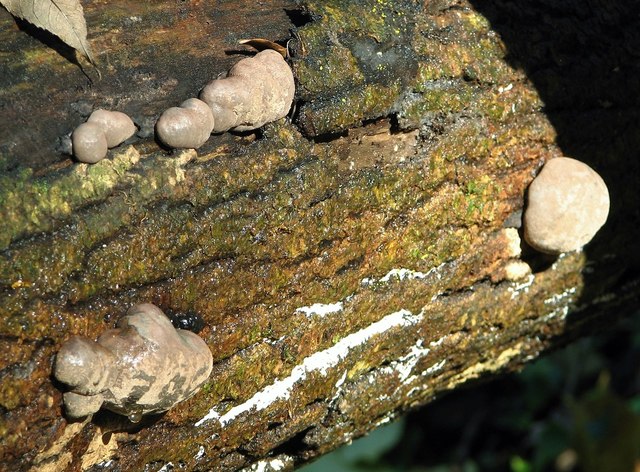
TG2105 : King Alfred's Cakes (Daldinia concentrica)
taken 4 years ago, near to Eaton, Norfolk, England
This is 1 of 9 images, with title King Alfred's Cakes (Daldinia concentrica) in this square
King Alfred's Cakes (Daldinia concentrica)
In Danby Wood. This fungus is commonly referred to as King Alfred's Cakes - having been given shelter by a peasant woman, King Alfred, preoccupied by other concerns, is reputed to have inadvertently allowed her cakes to burn despite his promise to watch them. They are also referred to as cramp balls due to the belief that carrying them would cure attacks of cramp. These widespread inedible fungi can commonly be found growing on dead ash and beech wood.
Danby Wood nature reserve
Danby Wood is a small broadleaved semi-natural woodland and one of eight local nature reserves in Norwich. Up until the 1930s the site was a working chalk quarry with many banks, hills and hollows that can still be seen today. The most common trees that colonised the site are sycamore and ash but lime, beech and oak are also present. The woodland supports a wide variety of birds and speckled wood, tortoiseshell and small white butterflies can be seen here during the summer months. The site is adjoined by the Eaton golf course and only a short distance away from the Marston Marshes. A public footpath linking both areas leads along the edge of the golf course.
 Map © Crown Copyright")
TIP: Click the map for more Large scale mapping
- Grid Square
- TG2105, 329 images (more nearby 🔍)
- Photographer
- Evelyn Simak (more nearby)
- Date Taken
- Monday, 2 December, 2019 (more nearby)
- Submitted
- Monday, 2 December, 2019
- Subject Location
-
OSGB36:
 TG 2192 0578 [10m precision]
WGS84: 52:36.2670N 1:16.5516E - Camera Location
-
OSGB36: TG 2192 0578
- View Direction
- East-northeast (about 67 degrees)