2019

TF0206 : Stamford Station, main platform

taken 4 years ago, near to Stamford, Lincolnshire, England
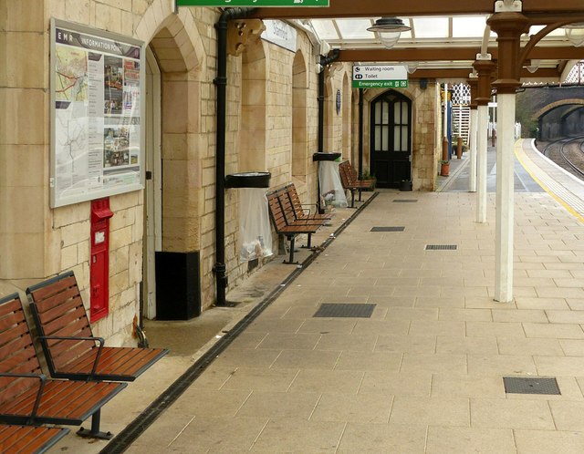
Stamford Station, main platform
Note the postbox Link on the platform itself. It was quite common in the Victorian period to install postboxes in this location, convenient for railway passengers, and where letters would often be collected shortly before the departure of trains for onward transfer.
Stamford Station

Stamford station opened in 1848. The station is 12.5 miles west of Peterborough opened by the Syston and Peterborough Railway, part of the present day Birmingham to Peterborough Line. CrossCountry operate the majority of services as part of their Birmingham to Stansted Airport route. It is owned by Network Rail and operated by East Midlands Trains.
The station was formerly known as Stamford Town to distinguish it from the now closed Stamford East station in Water Street.
The station building is a fine stone structure in Mock Tudor style, influenced by the nearby Burghley House, and designed by Sancton Wood.
Wikipedia: LinkExternal link


Creative Commons Licence [Some Rights Reserved]   © Copyright Alan Murray-Rust and licensed for reuse under this Creative Commons Licence.
Geographical Context: Historic sites and artefacts City, Town centre Railways Communications Period: Mid 19th Century Date: 1848 Style: Tudor Revival Postbox: Wall Box other tags: Railway Station Grade II Listed Click a tag, to view other nearby images.
This photo is linked from: Automatic Clusters: · Railway Station [27] · Platform [13] · Train [6] Other Photos: · Postbox, Stamford Station ·
1:50,000 Modern Day Landranger(TM) Map © Crown Copyright
+
+
1:50,000 Modern Day Landranger(TM) Map © Crown Copyright
TIP: Click the map for more Large scale mapping
Grid Square
TF0206, 459 images   (more nearby 🔍)
Photographer
Alan Murray-Rust   (more nearby)
Date Taken
Friday, 27 December, 2019   (more nearby)
Submitted
Monday, 30 December, 2019
Subject Location
OSGB36: geotagged! TF 0293 0665 [10m precision]
WGS84: 52:38.8698N 0:28.8025W
Camera Location
OSGB36: geotagged! TF 0291 0664
View Direction
East-northeast (about 67 degrees)
Clickable map
+
NW N NE
W Go E
SW S SE
Image Type (about): geograph 
This page has been viewed about 54 times
You are not logged in login | register