TG2523 : A memorial plaque to R.A.F. Coltishall
taken 9 years ago, near to Little Hautbois, Norfolk, England
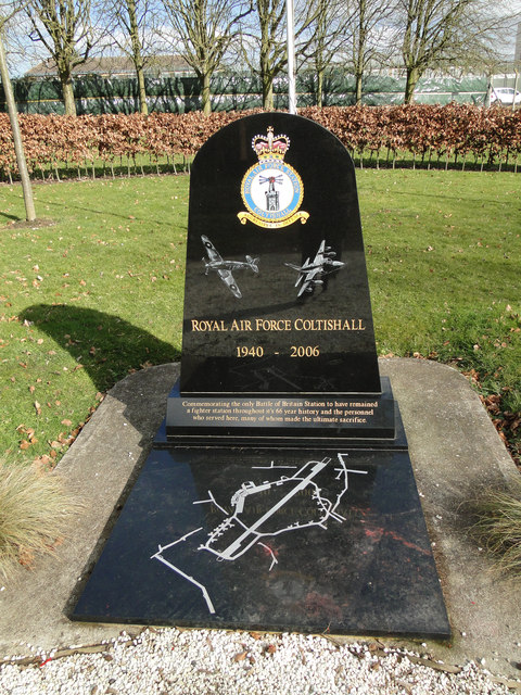
Work on RAF Coltishall was started in February 1939. The airfield, then known as Scottow Aerodrome and originally planned as a bomber airfield opened as a fighter airfield in the Second World War and afterwards, a station for night fighters then Strike Command aircraft until closure. During the Second World War, Coltishall operated the Hawker Hurricane, and a notable Coltishall fighter pilot was Douglas Bader. It later became home to night fighters. At the same time, the Royal Navy Fleet Air Arm operated aircraft from RAF Coltishall over the North Sea. From 10 February to 7 April 1945 it was the airfield for No. 124 Squadron RAF, at that time a fighter-bomber squadron flying Supermarine Spitfire IX.HF's. Postwar, the station was home to a variety of units and aircraft including de Havilland Mosquitoes, Gloster Javelins, English Electric Lightnings and - from 1963 - the "Historic Aircraft Flight" (now known as the Battle of Britain Memorial Flight). The last Lightnings left Coltishall in 1974, and were replaced by the Anglo-French SEPECAT Jaguar. The first Jaguar squadron, No. 54 Squadron RAF, arrived at Coltishall on 8 August 1974. Coltishall was also home to the yellow Search And Rescue (SAR) helicopters of 202 Sqn. Finally closed in 30 November 2006 and handed over to Defence Estates.
Royal Air Force and USAAF Station memorials, where they exist, have been erected on, or close to the airfield, primarily to honour those who served and to perpetuate the memory of those who lost their life during the Second World War.
They differ in size, from large, striking memorials, sometimes with flagpoles completing the setting, often with depictions of aircraft, squadron badges and the basic layout of the airfield itself etched into the memorial, to minimalist, and even almost commercial, but nevertheless equally sincere in their remembrance and gratitude to those who served and to the sacrifices made in times of war.
In many instances, much of the Air Station will have been demolished in the intervening years, and returned to agriculture, or converted into an industrial or housing estate, eventually to fade from the landscape altogether, but hopefully will remain a little longer in the memory of those who encounter the memorials along the roads and pathways.
Most were operational from 1939, until just after end of the War in 1945. The bases were home to brave young men and women who served the allied forces flying fighters and bombers from the runways of the airfield, sometimes never to return.
The station opened in 1939 as a fighter airfield during WW2. It later became a station for night fighters and then for ground attack aircraft until it was closed in 2006. Coltishall was the last surviving operational RAF airfield involved in the Battle of Britain other than RAF Northolt. The station was home to more than 80 fighter squadrons during its time of operation and 207 enemy aircraft were destroyed during the war. The airfield is currently owned by Norfolk County Council, with most of the former domestic site now being occupied by HMP Bure. See also: Link
 Map © Crown Copyright")
- Grid Square
- TG2523, 73 images (more nearby 🔍)
- Photographer
- Adrian S Pye (more nearby)
- Date Taken
- Friday, 27 February, 2015 (more nearby)
- Submitted
- Tuesday, 14 January, 2020
- Subject Location
-
OSGB36:
 TG 25696 23111 [1m precision]
WGS84: 52:45.5058N 1:20.6033E - Camera Location
-
OSGB36: TG 2568 2309
- View Direction
- Northeast (about 45 degrees)