2020
TA1028 : Old Harbour, River Hull, Kingston upon Hull
taken 4 years ago, near to Kingston Upon Hull, England
This is 1 of 141 images, with title Old Harbour, River Hull, Kingston upon Hull in this square
Old Harbour, River Hull, Kingston upon Hull
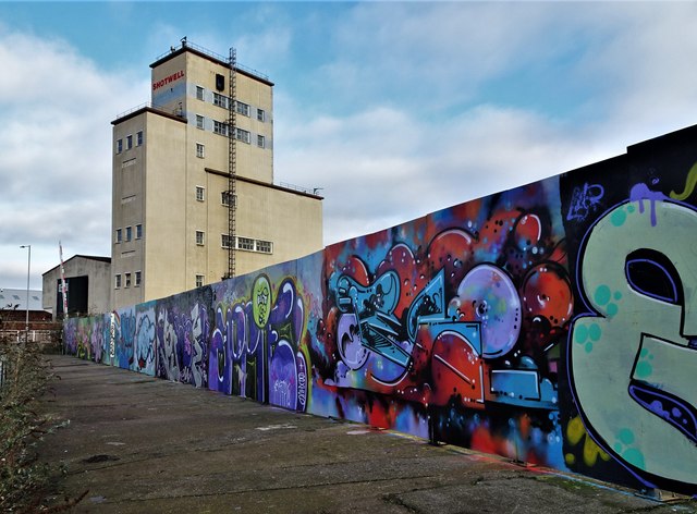
Graffiti covers the fence surrounding the vacant site of the former Clarence Flour Mills, bounded by Clarence Street, Harcourt Street, St Peter Street and the Old Harbour. The site is designated for future housing.
In the background, Gamebore Cartridge Co. Ltd., Great Union Street, has been a manufacturer of English shotgun cartridges for game and clay shooting since 1973. The Gamebore Shotwell Tower produces all of the company's lead shot onsite and is the only working shot tower in the UK. A shot tower is a tower designed for the production of shot balls by freefall of molten lead, which is then caught in a water basin. The Shotwell Tower was previously occupied by RHM Agriculture.
In the background, Gamebore Cartridge Co. Ltd., Great Union Street, has been a manufacturer of English shotgun cartridges for game and clay shooting since 1973. The Gamebore Shotwell Tower produces all of the company's lead shot onsite and is the only working shot tower in the UK. A shot tower is a tower designed for the production of shot balls by freefall of molten lead, which is then caught in a water basin. The Shotwell Tower was previously occupied by RHM Agriculture.
 Map © Crown Copyright")
TIP: Click the map for more Large scale mapping
- Grid Square
- TA1028, 3428 images (more nearby 🔍)
- Photographer
- Bernard Sharp (more nearby)
- Date Taken
- Friday, 24 January, 2020 (more nearby)
- Submitted
- Tuesday, 28 January, 2020
- Subject Location
-
OSGB36:
 TA 1040 2899 [10m precision]
WGS84: 53:44.7362N 0:19.6455W - Camera Location
-
OSGB36: TA 1036 2891
- View Direction
- North-northeast (about 22 degrees)