2020
NT0924 : Carlow's Bridge, Tweedsmuir
taken 4 years ago, near to Tweedsmuir, Scottish Borders, Scotland
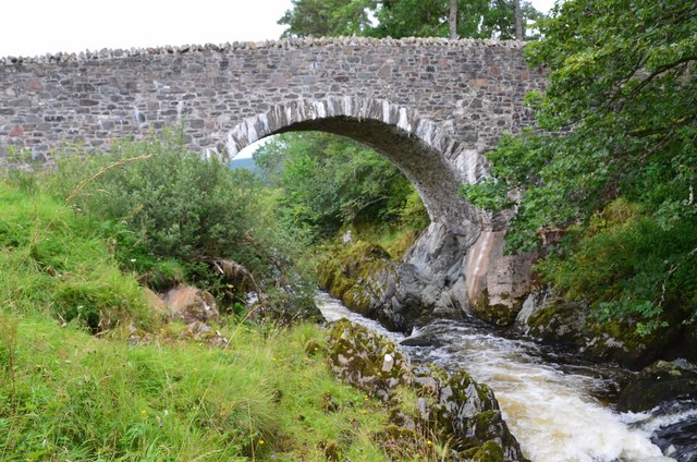
Carlow's Bridge, Tweedsmuir
This single arch stone bridge spans the young river Tweed at a narrow rocky passage known as Carlow's Linn or Carlowse Linn. It dates from 1783 and was built by two local stonemasons James and Alexander Noble.
In 2014 the bridge was temporarily closed for refurbishment and strengthening, since it carries timber traffic as well as being on the public road through the hills via Talla and Megget Reservoirs to St Mary's Loch - a popular scenic drive. The bridge re-opened in 2015.
(Source: Bridging the Tweed by Jim Lyon, author publication 2019).
 Map © Crown Copyright")
TIP: Click the map for more Large scale mapping
- Grid Square
- NT0924, 64 images (more nearby 🔍)
- Photographer
- Jim Barton (more nearby)
- Date Taken
- Sunday, 30 August, 2020 (more nearby)
- Submitted
- Wednesday, 2 September, 2020
- Subject Location
-
OSGB36:
 NT 0976 2433 [10m precision]
WGS84: 55:30.2627N 3:25.8143W - Camera Location
-
OSGB36: NT 0973 2430
- View Direction
- Northeast (about 45 degrees)