2020
NS5572 : Antonine Wall
taken 4 years ago, near to Bearsden, East Dunbartonshire, Scotland
This is 1 of 2 images, with title Antonine Wall in this square
Antonine Wall
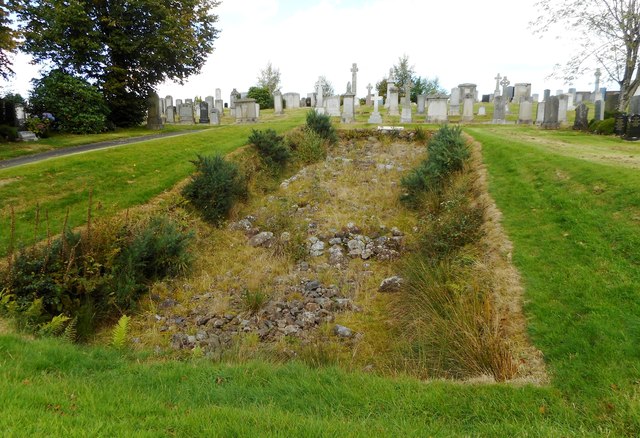
This is one of two short sections of the Antonine Wall visible within New Kilpatrick Cemetery. Both are Scheduled Monuments Link and part of the Antonine Wall World Heritage Site Link. The remains of the stone base of the rampart are well preserved and show various distinctive features of construction. The cemetery, which was opened in 1903, has been built over the rest of the Wall at this point.
The site is currently getting rather overgrown.
The site is currently getting rather overgrown.
New Kilpatrick Cemetery
The cemetery, also known as Hillfoot Cemetery, opened in 1903, and is on the northern side of Boclair Road. Between the Wars (c.1922), it was extended to the north. Its former lodge, at the SW corner, is now a private residence. The line of the Antonine Wall passes through the cemetery, changing direction near the crest of the hill, and two sections of the stone base of the Wall are preserved and open to view (one since 1903, the other since 1921). As mentioned in the cemetery's listing text Link
 Map © Crown Copyright")
TIP: Click the map for more Large scale mapping
- Grid Square
- NS5572, 246 images (more nearby 🔍)
- Photographer
- Richard Sutcliffe (more nearby)
- Date Taken
- Sunday, 6 September, 2020 (more nearby)
- Submitted
- Sunday, 6 September, 2020
- Subject Location
-
OSGB36:
 NS 5564 7235 [10m precision]
WGS84: 55:55.3499N 4:18.7065W - Camera Location
-
OSGB36: NS 5564 7234
- View Direction
- North-northeast (about 22 degrees)