2003
TG1901 : Old Milestone (south face) by the B1113, north of Mulbarton
taken 21 years ago, near to Mulbarton, Norfolk, England
This is 1 of 3 images, with title starting with Old in this square
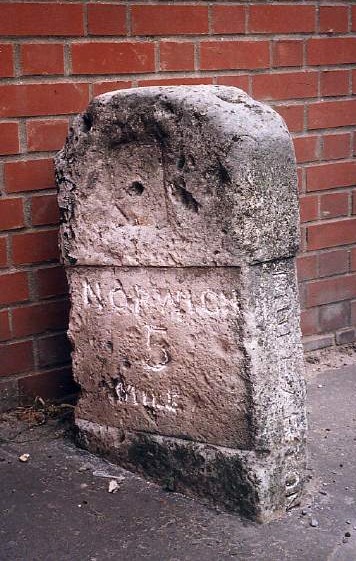
Old Milestone (south face) by the B1113, north of Mulbarton
Carved stone post by the B1113, in parish of MULBARTON (SOUTH NORFOLK District), Right hand side of the Methodist Chapel, Left of Worlds End pub, against brick wall, in pavement, on West side of road. New Buckenham wedge, erected by the New Buckenham turnpike trust in the 19th century.
Inscription reads:- : NORWICH / 5 / MILES : : MULBARTON : : NEW BUCKENHAM / 10 / MILES / LONDON / (104 MILES)
Listed.
Milestone Society National ID: NO_NNB05.
Inscription reads:- : NORWICH / 5 / MILES : : MULBARTON : : NEW BUCKENHAM / 10 / MILES / LONDON / (104 MILES)
Listed.
Milestone Society National ID: NO_NNB05.
National Survey of Wayside Features by The Milestone Society
These images are from Link
 Map © Crown Copyright")
TIP: Click the map for more Large scale mapping
- Grid Square
- TG1901, 115 images (more nearby 🔍)
- Photographer
- CW Haines (more nearby)
- Contributed by
- Milestone Society (more nearby)
- Date Taken
- Friday, 26 September, 2003 (more nearby)
- Submitted
- Tuesday, 22 September, 2020
- Subject Location
-
OSGB36:
 TG 19314 01275 [1m precision]
WGS84: 52:33.9043N 1:14.0676E - Camera Location
-
OSGB36: TG 19314 01275
- View Direction
- North-northwest (about 337 degrees)