TQ2678 : Gloucester Road Station
taken 4 years ago, near to Kensington, Kensington And Chelsea, England
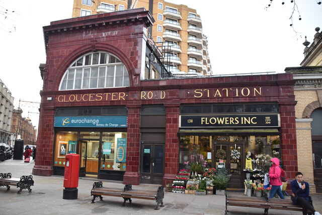
Gloucester Road is a London Underground station in Kensington, west London. It is served by the District, Circle and Piccadilly lines. On the District and Piccadilly lines, the station is between South Kensington and Earl's Court, and on the Circle line, it is between South Kensington and High Street Kensington. It is in London fare zone 1. The station entrance is located close to the junction of Gloucester Road and Cromwell Road.
The station is in two parts: sub-surface platforms, opened in 1868 by the Metropolitan Railway as part of the company's extension of the Inner Circle route from Paddington to South Kensington and to Westminster, and deep-level platforms opened in 1906 by the Great Northern, Piccadilly and Brompton Railway.
Grade II listed. Link
Wikipedia: Link
A few years ago I read a book by Mark Mason "Walking the lines" in which he walked the route of the London Underground lines, overground. I will repeat this visiting all 272 stations (some more than once). My route tries to follow the line of the railway as closely as possible, using footpaths and roads, deviations are made to make the walk more "interesting".
The London Underground system is also known as the "Tube". It is the oldest underground system in the world, the first section dating from 1863. The present system has over 250 miles of track and 272 stations. There are 11 lines covering Greater London, Essex, Buckinghamshire & Hertfordshire. Nearly half the system is above ground.
Wikipedia: Link
Transport for London: Link
Listed buildings and structures are officially designated as being of special architectural, historical or cultural significance. There are over half a million listed structures in the United Kingdom, covered by around 375,000 listings.
Listed status is more commonly associated with buildings or groups of buildings, however it can cover many other structures, including bridges, headstones, steps, ponds, monuments, walls, phone boxes, wrecks, parks, and heritage sites, and in more recent times a road crossing (Abbey Road) and graffiti art (Banksy 'Spy-booth') have been included.
In England and Wales there are three main listing designations;
Grade I (2.5%) - exceptional interest, sometimes considered to be internationally important.
Grade II* (5.5%) - particularly important buildings of more than special interest.
Grade II (92%) - nationally important and of special interest.
There are also locally listed structures (at the discretion of local authorities) using A, B and C designations.
In Scotland three classifications are also used but the criteria are different. There are around 47,500 Listed buildings.
Category A (8%)- generally equivalent to Grade I and II* in England and Wales
Category B (51%)- this appears generally to cover the ground of Grade II, recognising national importance.
Category C (41%)- buildings of local importance, probably with some overlap with English Grade II.
In Northern Ireland the criteria are similar to Scotland, but the classifications are:
Grade A (2.3%)
Grade B+ (4.7%)
Grade B (93%)
Read more at Wikipedia Link
 Map © Crown Copyright")
- Grid Square
- TQ2678, 695 images (more nearby 🔍)
- Photographer
- N Chadwick (more nearby)
- Date Taken
- Sunday, 15 December, 2019 (more nearby)
- Submitted
- Wednesday, 7 October, 2020
- Subject Location
-
OSGB36:
 TQ 2625 7883 [10m precision]
WGS84: 51:29.6595N 0:10.9664W - Camera Location
-
OSGB36: TQ 2627 7884
- View Direction
- West-southwest (about 247 degrees)