TQ2678 : Piccadilly Line, South Kensington Station
taken 4 years ago, near to Chelsea, Kensington And Chelsea, England
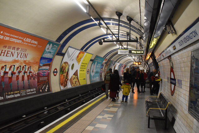
South Kensington is a London Underground station in the district of Kensington. It is served by the District, Circle and Piccadilly lines. On the District and Circle lines, the station is between Gloucester Road and Sloane Square, and on the Piccadilly line, it is between Gloucester Road and Knightsbridge. It is in Travelcard Zone 1. The main station entrance is located at the junction of Old Brompton Road (A3218), Thurloe Place, Harrington Road, Onslow Place and Pelham Street. Subsidiary entrances are located in Exhibition Road giving access by pedestrian tunnel to the Natural History, Science and Victoria and Albert Museums. Also close by are the Royal Albert Hall, Imperial College London, the Royal College of Music, the London branch of the Goethe-Institut and the Ismaili Centre.
The station is in two parts: sub-surface platforms opened in 1868 by the Metropolitan Railway and the District Railway as part of the companies' extension of the Inner Circle route eastwards from Gloucester Road to Westminster and deep level platforms opened in 1906 by the Great Northern, Piccadilly and Brompton Railway.
Grade II listed. Link
Wikipedia: Link
The London Underground system is also known as the "Tube". It is the oldest underground system in the world, the first section dating from 1863. The present system has over 250 miles of track and 272 stations. There are 11 lines covering Greater London, Essex, Buckinghamshire & Hertfordshire. Nearly half the system is above ground.
Wikipedia: Link
Transport for London: Link
A few years ago I read a book by Mark Mason "Walking the lines" in which he walked the route of the London Underground lines, overground. I will repeat this visiting all 272 stations (some more than once). My route tries to follow the line of the railway as closely as possible, using footpaths and roads, deviations are made to make the walk more "interesting".
 Map © Crown Copyright")
- Grid Square
- TQ2678, 695 images (more nearby 🔍)
- Photographer
- N Chadwick (more nearby)
- Date Taken
- Sunday, 15 December, 2019 (more nearby)
- Submitted
- Thursday, 8 October, 2020
- Subject Location
-
OSGB36:
 TQ 2687 7882 [10m precision]
WGS84: 51:29.6458N 0:10.4310W - Camera Location
-
OSGB36: TQ 2687 7881
- View Direction
- North-northeast (about 22 degrees)