TQ4736 : Forest Way
taken 4 years ago, near to Hartfield, East Sussex, England
The Forest Way is approximately 10 miles long and is used for walking, cycling, horse riding and the quiet enjoyment of the countryside. It runs from East Grinstead to Groombridge.
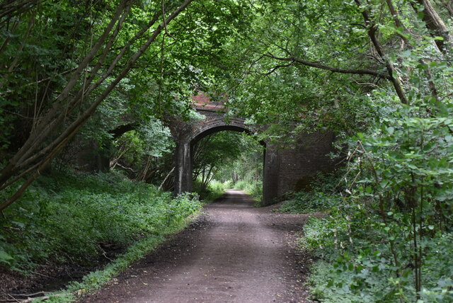
The Forest Way runs along an old railway line and is an important habitat for wildlife as a green corridor'.
The way lies within the Forest Way Country Park. The Park lies within the High Weald Area of Outstanding Natural Beauty and passes through or close to East Grinstead, Forest Row, Hartfield, Withyham and Groombridge. There are circular trails varying in length and difficulty. Walkers may spot swallows, badger tracks, deer and foxes, amongst the fields and woodlands.
The way follows the line of the old East Grinstead to Groombridge railway. The railway opened in 1866. Although a busy commuter line, it was axed with the Beeching cuts in 1966. Ironically, Dr Beeching lived near Forest Row and regularly travelled up to London on the line when he was Chairman of British Rail.
East Sussex County Council bought the line in 1971 and it was designated as a Country Park in 1974. In 2002, following improvements to the surfaced track Forest Way became part of the National Cycle Network.
The Park is owned by East Sussex County Council and managed by its Countryside Management Service.
The Sussex Border Path runs along this stretch as well. It is a 150 mile route following the inland border of the county from Thorney Island in West Sussex to Rye in East Sussex
The route is shared with National Cycle Network Route 21. Link
Route 21 of The National Cycle Network runs south from Greenwich out of London through Lewisham (the Waterlink Way) to Crawley, and then via East Grinstead and Eridge to Heathfield and Eastbourne, a distance of 95 miles.
The section between Groombridge and East Grinstead follows the Forest Way. Link
See Linkfor a map of the route.
 Map © Crown Copyright")
- Grid Square
- TQ4736, 187 images (more nearby 🔍)
- Photographer
- N Chadwick (more nearby)
- Date Taken
- Monday, 29 June, 2020 (more nearby)
- Submitted
- Sunday, 20 December, 2020
- Subject Location
-
OSGB36:
 TQ 4767 3616 [10m precision]
WGS84: 51:6.3435N 0:6.4758E - Camera Location
-
OSGB36: TQ 4773 3617
- View Direction
- WEST (about 270 degrees)