1966
TQ8209 : Hampton Court at Rock-a-Nore, Hastings Miniature Railway 1966
taken 58 years ago, near to Hastings, East Sussex, England
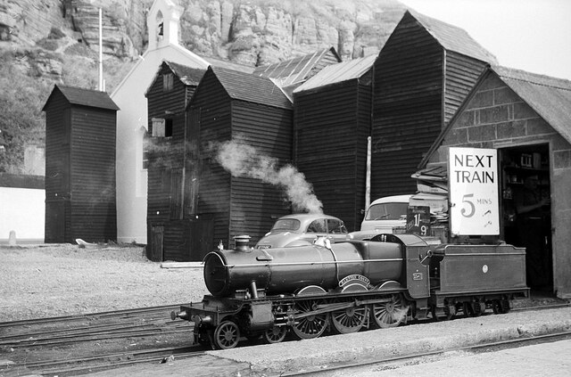
Hampton Court at Rock-a-Nore, Hastings Miniature Railway 1966
This was during the period when the railway was owned by Ian Allan. The locomotive was rebuilt as a Great Western Railway 'Saint' class after coming to the railway in 1958 and was sold to Stapleford Park in 1974. The railway no longer operates steam locomotives.
This end of the railway is adjacent to the iconic fishing huts and the former seamen's chapel, now the Fishermen's Museum. Here is the same view in 2015 Link
This end of the railway is adjacent to the iconic fishing huts and the former seamen's chapel, now the Fishermen's Museum. Here is the same view in 2015 Link
Hastings Miniature Railway
The 10.25 inch (260mm) gauge railway runs from Rock-a-Nore for 600 yards (550m) to Marine Parade. It is open seasonally in the spring and summer.
Fishing Net Huts
The huts were used to store fishing nets and equipment. The weatherboarded structures were around 25 feet high and 8 feet square. Due to the lack of space the huts were restricted to 8 square feet at the base, so they were built tall.
There are around 43 remaining in Hastings, which were Grade II listed in the 1970s. Most are found to the Fishermans Stade along Rock-A-Nore Road There were once many more which were destroyed by storms or demolished in the 1950s for redevelopment.
 Map © Crown Copyright")
TIP: Click the map for more Large scale mapping
- Grid Square
- TQ8209, 4355 images (more nearby 🔍)
- Photographer
- Alan Murray-Rust (more nearby)
- Date Taken
- 11 September 1966 (more nearby)
- Submitted
- Monday, 4 January, 2021
- Subject Location
-
OSGB36:
 TQ 8274 0947 [10m precision]
WGS84: 50:51.3523N 0:35.6976E - Camera Location
-
OSGB36: TQ 8273 0946
- View Direction
- Northeast (about 45 degrees)