2021
SX2671 : Old Boundary Marker on Caradon Hill
taken 3 years ago, near to Minions, Cornwall, England
This is 1 of 2 images, with title Old Boundary Marker on Caradon Hill in this square
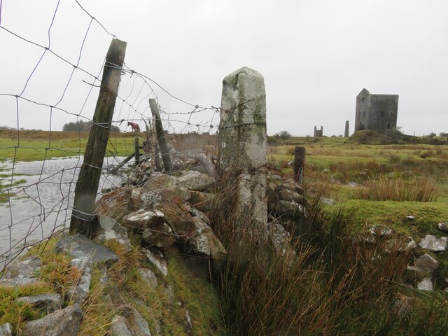
Old Boundary Marker on Caradon Hill
Estate Boundary Marker at the junction of the old Cornish Hedges that form part of the parish boundary of Linkinhorne and St Cleer, and the enclosed farmland to the east of Minions. Inscribed 3 RIL 1846 (vertically).
One of a series of ten impressive obelisk shaped stones and two boundary rocks that marked the boundary of the unenclosed moorland owned by the nearby Duchy of Cornwalls now demolished Rillaton Manor. All of the boundary markers are on open moorland, with the exception of 1 RIL which is on private land but clearly visible from the lane from Minions to Higher Stanbear, and 5 RIL which is in the garden of a house in Minions Village.
Milestone Society National ID: CW_LINRIL03em
National Survey of Wayside Features by The Milestone Society
These images are from Link
 Map © Crown Copyright")
TIP: Click the map for more Large scale mapping
- Grid Square
- SX2671, 86 images (more nearby 🔍)
- Photographer
- P G Moore (more nearby)
- Contributed by
- Mike Rayner (more nearby)
- Date Taken
- January 2021 (more nearby)
- Submitted
- Saturday, 30 January, 2021
- Subject Location
-
OSGB36:
 SX 26394 71168 [1m precision]
WGS84: 50:30.8695N 4:27.0032W - Camera Location
-
OSGB36: SX 26394 71168