NO7047The spectacular stretch of coastline in NO 7047 rises to a height of 81 metres as is shown by the OS triangulation pillar there. The sandstone headland of Red Head has long been a significant feature to people living in the area as it was selected as the site for what is thought to be an Iron Age fort. Although Red Head fits a geographical pattern of promontory forts, it is, perhaps, surprising that this archaeological discovery was not made until 1961, when Mr and Mr J Wilson distinguished the different parts of the fort including a broad ditch, a causeway and a single rampart. Because of its commanding position and sea vistas, Red Head was used for coastal defences during WW1. A lookout post was built and slit trenches were dug in support of it. Unfortunately, the effects of these military uses have combined to obscure the site and have made archaeological interpretation more difficult. Particularly in summer, the difficulty of understanding the site is compounded by the lush vegetation that grows there. However, despite these difficulties, it is clear that the promontory fort at Red Head is the most northerly in a line of six forts which stretch along the six mile distance between Arbroath and Lunan Bay.
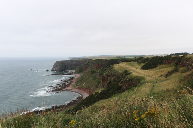
Although the centrepiece of this Geological Conservation Review site (GCR), in NO 7047, is the towering Red Head cliff itself, there are other notable cliffs such as East Comb and Auld Mains. Looking northwards to Auld Mains, exposures of Ethie Lavas are revealed. These are a series of andesite rocks, belonging to the Montrose Volcanic Formation, intercalated with sandstone, siltstone and agglomerates of the Lower Devonian Arbuthnott Group. These rocks add further diversity to the landscape and ecology of the area. Running close to the shore, there are a myriad of small fringing islands which have been separated from the mainland by erosion. Particularly, on a sunny day, these can appear like a necklace of jewels adorning the coast.
The remains of the medieval St Murdochs Chapel are situated in an isolated location near Kirk Loch. This place of worship was connected to Arbroath Abbey and it was formerly the church of the local area. It was not served by road and the parishioners would have had to walk some miles in order to attend Sunday services and ceremonies including christening, marriage and funerals. The church was closed around 1611 and little now remains save a crumbling, east gable wall. Despite its ruined appearance, however, St Murdochs Chapel is scheduled as a monument of national importance as it has the inherent potential to further the understanding of early church sites in Scotland. Soay sheep frequent this area and they are an interesting addition to the wildlife which tends to be dominated by sea birds including cormorants and kittiwakes. Plants and butterflies add further variety to the ecological diversity of the area.
Partly because Red Head was easily visible from the sea, it came to be designated as the geographical point beyond which the tax on coal was increased. After David Scott (1746-1805) and his wife, Louisa, returned to Scotland and his family home at Dunninald, the former Chairman of the East India Company became the MP for Forfarshire, (Angus). As the new owner of the family lime kilns at Boddin Point, he needed large amounts of coal to burn the limestone and make lime. It is not surprising, therefore, that he legislated the repeal of the unpopular excise duty on coal shipments which were carried north of Red Head.
The difficulty of access to NO 7047 is an enduring one in that the only road serving Red Head is a farm track across the fields. The clifftop, car park is only large enough to accommodate a few vehicles and consequently the area is seldom visited by many people at the same time. With the coast of Angus being one of its glories, there have long been calls, by some, for a continuous, coastal path. That call, however, is not a universal one as others take the view that, particularly in elemental places like Red Head, assets like the majestic cliffs, the declining numbers of seabirds and the solitude of the place are best shared by a few visitors at a time and particularly by those who have invested time and effort into getting there. This perspective does not view a land use change, like that of a coastal path, as being good management of the land as it is not a desirable outcome that Red Head becomes a honeypot site. What do you think?
Adrian Diack, M.A. (Hons.)
NO7047 : Red Head, Marshall's Craig and Auld Mains, AngusNO7047 : Southward view of Red Head and fringing islands, AngusNO7047 : Farm track serving as a coastal path at Red Head, AngusNO7047 : The position of St Murdoch's ChapelNO7047 : Coast between East Comb and Auld Mains
 Map © Crown Copyright")
 NO 7006 4714 [10m precision]