1994
SJ4166 : Drury House, Chester - September 1994
taken 30 years ago, near to Hoole, Cheshire West And Chester, England
Drury House, Chester - September 1994
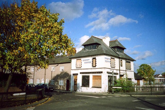
Drury House is located at the southern end of Westminster Road at the junction with Lightfoot Street. It was designed by Chester based architect John Douglas as a public house and built in 1877, however due to objections by the local temperance movement it was never granted a licence. It served as a shop and off-licence until the 1980s when it was sold as a private residence but due to its unusual design the building remained on the market for many years. This photo shows Drury House still boarded up in 1994. See also the same building in 2016 SJ4166 : Road Junction on Lightfoot Street, Chester
Source: Hoole History & Heritage Society
Source: Hoole History & Heritage Society
 Map © Crown Copyright")
TIP: Click the map for more Large scale mapping
- Grid Square
- SJ4166, 1167 images (more nearby 🔍)
- Photographer
- Jeff Buck (more nearby)
- Date Taken
- September 1994 (more nearby)
- Submitted
- Monday, 1 March, 2021
- Subject Location
-
OSGB36:
 SJ 4174 6692 [10m precision]
WGS84: 53:11.7692N 2:52.4112W - Camera Location
-
OSGB36: SJ 4172 6690
- View Direction
- Northeast (about 45 degrees)