1968
SP1954 : The LMS Station, road side, Stratford-upon-Avon
taken 56 years ago, near to Stratford-Upon-Avon, Warwickshire, England
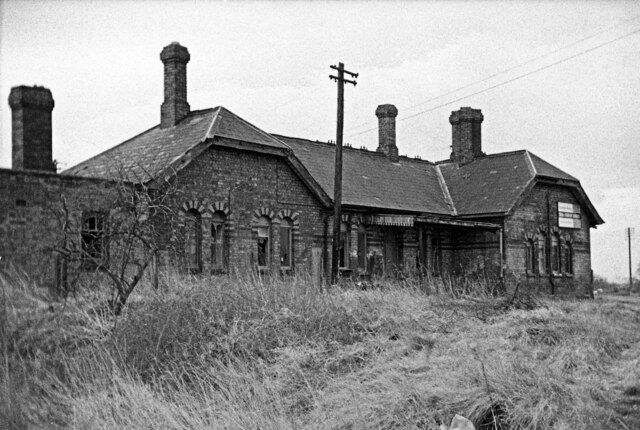
The LMS Station, road side, Stratford-upon-Avon
The LMS Station at Stratford was the only station of any importance on the Stratford-upon-Avon & Midland Junction Railway - a rural trailway that meandered across the southern midlands from Ravenstone Wood Junc (near Bedford) in the east, to Broom Junc (near Alcester) in the west.
Withdrawal of the passenger service inevitably came early; that to the west of Stratford ended in May 1949, & that to the east in April 1952. It remained open as a through route for goods trains (notably ore trains from Northamptonshire to South Wales) until 1960. West of Stratford then closed completely, but a goods service to Stratford from the east lasted until 1965. The notice at the far gable suggests the building is up for sale. All has gone now though & the trackbed has been used for the A4390. For a view of the rail-side elevation see: SP1954 : The LMS Station, rail side, Stratford-upon-Avon.
Withdrawal of the passenger service inevitably came early; that to the west of Stratford ended in May 1949, & that to the east in April 1952. It remained open as a through route for goods trains (notably ore trains from Northamptonshire to South Wales) until 1960. West of Stratford then closed completely, but a goods service to Stratford from the east lasted until 1965. The notice at the far gable suggests the building is up for sale. All has gone now though & the trackbed has been used for the A4390. For a view of the rail-side elevation see: SP1954 : The LMS Station, rail side, Stratford-upon-Avon.
 Map © Crown Copyright")
TIP: Click the map for more Large scale mapping
- Grid Square
- SP1954, 331 images (more nearby 🔍)
- Photographer
- Martin Tester (more nearby)
- Date Taken
- March 1968 (more nearby)
- Submitted
- Sunday, 21 March, 2021
- Subject Location
-
OSGB36:
 SP 19900 54047 [1m precision]
WGS84: 52:11.0589N 1:42.6213W - Camera Location
-
OSGB36: SP 1988 5407
- View Direction
- South-southeast (about 157 degrees)