2007
TG2223 : Brampton (Norfolk) village sign
taken 17 years ago, near to Brampton, Norfolk, England
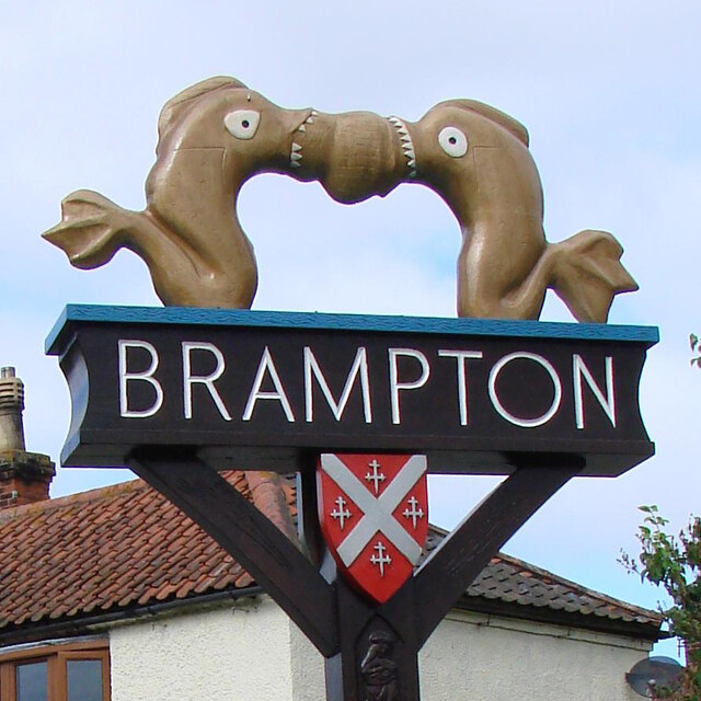
Brampton (Norfolk) village sign
They are thought to be dolphins, and are based on an artefact discovered in Brampton during an excavation in 1974. Made of copper alloy, they are thought to have formed a decorative handle for an item of Roman furniture. When in use the dolphins would usually be seen inverted.
On each facet of the post are carvings. Two crossed keys representing the church of St Peter, and or the former Cross Keys public house. Because around 140 kilns have been discovered in the parish a number of pots are carved onto another. A Roman galleon is shown on the River Bure which was navigable to large ships during the Roman period. The fourth carving, seemingly of the Virgin Mary, may allude to Maid's Head, another pub which closed in 1962. The shields represent the Brampton and a marriage between the Brampton and Marsham family. Link
On each facet of the post are carvings. Two crossed keys representing the church of St Peter, and or the former Cross Keys public house. Because around 140 kilns have been discovered in the parish a number of pots are carved onto another. A Roman galleon is shown on the River Bure which was navigable to large ships during the Roman period. The fourth carving, seemingly of the Virgin Mary, may allude to Maid's Head, another pub which closed in 1962. The shields represent the Brampton and a marriage between the Brampton and Marsham family. Link
Village Signs of East Anglia
Village signs are typically placed along the principal road or in a prominent location such as a village green or close by the church. The design often depicts a particularly feature of the village or a scene from its history, heritage, or culture. They are typically made of wood or metal or a combination of both, the designs are often made by the local community.
Although they do appear in villages and towns all over the country they are more prominent in East Anglia than elsewhere in the country.
 Map © Crown Copyright")
TIP: Click the map for more Large scale mapping
- Grid Square
- TG2223, 75 images (more nearby 🔍)
- Photographer
- Adrian S Pye (more nearby)
- Date Taken
- Tuesday, 11 September, 2007 (more nearby)
- Submitted
- Monday, 5 April, 2021
- Subject Location
-
OSGB36:
 TG 22312 23971 [1m precision]
WGS84: 52:46.0530N 1:17.6347E - Camera Location
-
OSGB36: TG 2231 2397
- View Direction
- West-southwest (about 247 degrees)