1988
SO8218 : From a Severnside field - Gloucester, Gloucestershire
taken 36 years ago, near to Gloucester, Gloucestershire, England
From a Severnside field - Gloucester, Gloucestershire
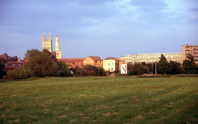
In the centre of this photo on the left bank of the River Severn the rear view of the Old Custom House. It was in use from about 1700 - 1800 with a late 18th century addition to the front to provide extra accommodation. It was Grade II listed on the 23rd January 1952 by English Heritage. On the left is the Cathedral tower and then the spire of the 12th century St Nicholas Church in Westgate Street. This church was listed Grade I on the 23rd January 1952 by English Heritage. It was declared redundant in 1971 and handed over to the Redundant Churches Fund. On the right is the multi-storey bulk of the Gloucestershire County Council's Shire Hall. Time photo taken not available.
 Map © Crown Copyright")
TIP: Click the map for more Large scale mapping
- Grid Square
- SO8218, 1309 images (more nearby 🔍)
- Photographer
- Martin Richard Phelan (more nearby)
- Date Taken
- June 1988 (more nearby)
- Submitted
- Tuesday, 6 April, 2021
- Subject Location
-
OSGB36:
 SO 8272 1876 [10m precision]
WGS84: 51:52.0288N 2:15.1419W - Camera Location
-
OSGB36: SO 8249 1881
- View Direction
- East-southeast (about 112 degrees)