2021
NT0573 : Commonwealth War Graves, Ecclesmachan Cemetery
taken 3 years ago, near to Ecclesmachan, West Lothian, Scotland
Commonwealth War Graves, Ecclesmachan Cemetery
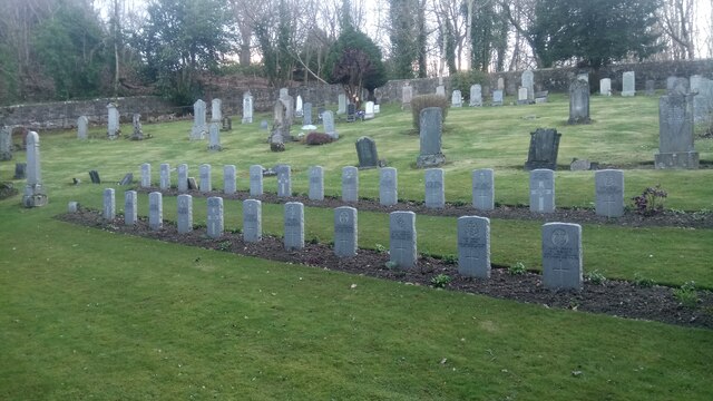
According to the official website there are 27 'identified casualties' here. All the standard headstones are in the photograph and they total 25. There is a larger monument, off camera, just to the right, and a smaller stone sits at the far left of the front row, so perhaps they make up the extra two.
Apart from the fact that some of the graves put the emblem of the regiment (if that is the official catch-all word) in the centre of a cross, and others have them separate, the graves are very uniform. Apparently this was a conscious decision, as it was decided that every death was of equal significance, irrespective of rank.
Some of the wordings can just be made out in the front row and there are two 46 year olds commemorated in it, which came as a surprise. As did the fact that the 46 year old whose grave is at the far right, died in 1920. This is because even though the First World War ended in 1918, and the Versailles Treaty was signed in 1919, it wasn't done with American consent. A further peace treaty was signed between America and Germany in August 1921, and so this, rather strangely, is the official end of the war as far as the Commonwealth War Graves Commission is concerned.
The six countries who oversee the commission are the UK, Australia, New Zealand, India, Canada and South Africa.
 Map © Crown Copyright")
TIP: Click the map for more Large scale mapping
- Grid Square
- NT0573, 33 images (more nearby 🔍)
- Photographer
- Ian Dodds (more nearby)
- Date Taken
- Tuesday, 6 April, 2021 (more nearby)
- Submitted
- Tuesday, 6 April, 2021
- Subject Location
-
OSGB36:
 NT 057 736 [100m precision]
WGS84: 55:56.7692N 3:30.6898W - Camera Location
-
OSGB36: NT 057 736
- View Direction
- South-southwest (about 202 degrees)