2016
TR1458 : Former Church of the Holy Cross, St Dunstan's Street, Canterbury
taken 8 years ago, near to Canterbury, Kent, England
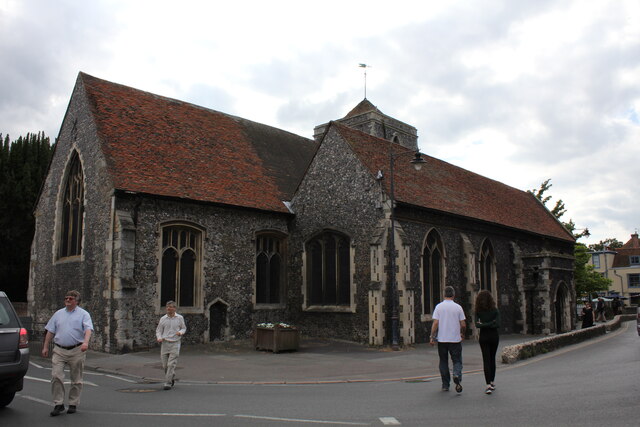
Former Church of the Holy Cross, St Dunstan's Street, Canterbury
Grade II* Listed church built 1381 with some 15th century windows. Parish records date back to 1563 and up to 1973 when the church became redundant and was converted to a Guildhall in 1978. Described in 1992 as 'mutilated and heavily restored', it was built by Archbishop Sudbury replacing the church that was above the west gate when he rebuilt that in 1380. The church is frequently referred to simply as Westgate Church. A 1552 inventory lists four bells plus a Sanctus bell that was increased to five in 1730 by a bell that was re-cast or replaced in 1739. Three of the other four were early 17th century by Joseph Hatch of Ulcombe, the fourth a rare, possibly 14th century, bell marked 'Stephorus Nortone de Kent me fecit' that was heavily restored in the late 19th century when a new pyramid roof was put on. The bells were removed to the Whitechapel bell foundry in 1972 and on to St Saviour's, Westgate on Sea. The porch, altered in 1844, was cut off and reduced to be very shallow in early 19th century during road widening and in 1877 it was reported that 'This church has been thoroughly repaired, restored and rearranged; the tower more recently, has been rebuilt'. The Guildhall was officially opened by Prince Charles, the Prince of Wales on 9 November 1978.
 Map © Crown Copyright")
TIP: Click the map for more Large scale mapping
- Grid Square
- TR1458, 1354 images (more nearby 🔍)
- Photographer
- Jo and Steve Turner (more nearby)
- Date Taken
- Tuesday, 5 July, 2016 (more nearby)
- Submitted
- Sunday, 11 April, 2021
- Subject Location
-
OSGB36:
 TR 1460 5805 [10m precision]
WGS84: 51:16.8691N 1:4.5470E - Camera Location
-
OSGB36: TR 1462 5805
- View Direction
- WEST (about 270 degrees)