NS3938 : Elizabethan postbox on Kilmarnock Road, Crosshouse
taken 3 years ago, near to Crosshouse, East Ayrshire, Scotland
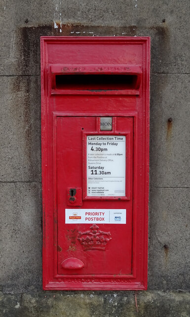
Postbox No. KA2 64.
See NS3938 : Post Office and shop on Kilmarnock Road, Crosshouse for context.
When the late queen acceded to the throne in February 1952, she chose the title Queen Elizabeth II which was reflected in her royal cypher, which took the Latin form 'EIIR'. As was traditional this was applied to newly installed postboxes throughout the UK.
Unfortunately this was to cause problems to some people in Scotland who objected on the grounds that there had never been a Queen Elizabeth I of Scotland. This led to vandalism to those postboxes which bore the new EIIR cypher. One particular example in Edinburgh was subjected to repeated attacks before being blown to pieces less than three months after its unveiling.
It therefore came to pass that any new postbox installed in Scotland from 1953 would bear the Crown of Scotland image rather than the EIIR cypher.
A post box with the EIIR cypher installed in Dunoon by 'error' in 2018 had to be replaced shortly after being discovered. There may however be still some examples in Scotland which bear the EIIR cypher which have yet to be discovered.
Strangely there seems to be no objections to the postboxes bearing the cyphers of Edward VII and Edward VIII on similar grounds.
 Map © Crown Copyright")
- Grid Square
- NS3938, 88 images (more nearby 🔍)
- Photographer
- JThomas (more nearby)
- Date Taken
- Sunday, 23 May, 2021 (more nearby)
- Submitted
- Saturday, 5 June, 2021
- Subject Location
-
OSGB36:
 NS 3933 3836 [10m precision]
WGS84: 55:36.7338N 4:33.1487W - Camera Location
-
OSGB36: NS 3933 3836
- View Direction
- Northeast (about 45 degrees)