ST5673 : The West Tower, Clifton Suspension Bridge
taken 3 years ago, near to Leigh Woods, North Somerset, England
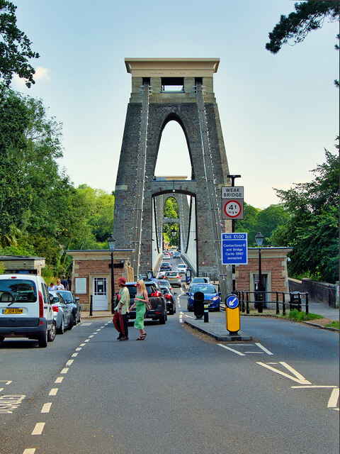
Clifton Suspension Bridge is one of Bristols most recognisable structures. The bridge spans the Avon Gorge and the River Avon, linking Clifton in Bristol to Leigh Woods in North Somerset forming part of the B3129 road.
Clifton Suspension Bridge was designed by Isambard Kingdom Brunel. A young and innovative engineer, he was 24 when he was appointed for the project which came about through a competition. Work began on 21st June 1831. However, in the following October, the Bristol Riots Linkbroke out across the city. They were sparked by tensions over proposed voting reform. Investment in the bridge dropped and work slowed. By 1843 the abutments and towers, excavations for both approach roads and the tunnels and chambers in the rocks for anchoring the chains were complete but funds had run out, work ceased and the project was abandoned. Brunel died in 1859, without seeing the completion of his bridge. His colleagues in the Institution of Civil Engineers felt that completion of the Bridge would be a fitting memorial, and started to raise new funds. The bridge was completed in 1864 to a revised version of Brunels plan by William Henry Barlow and Sir John Hawkshaw (ST5673 : Memorial Plaque on the Clifton Suspension Bridge).
Since opening in 1864, it has been operated as a toll bridge, the income from which provides funds for its maintenance. It is a Grade I listed building (Historic England List Entry Number: 1205734 Link
Architectural interest, a remarkable engineering feat, spanning the Avon Gorge over 214m, and 75m above high water using the suspension method; reuse of chains from Brunels Hungerford Bridge, demolished in 1860; substantially intact with little engineering intervention, despite increased traffic load; as a major landmark and icon within the Avon Gorge and Bristols urban landscape.
Historic interest: the major Bristol work of Isambard Kingdom Brunel; completed after Brunels death as a memorial to him.
 Map © Crown Copyright")
- Grid Square
- ST5673, 932 images (more nearby 🔍)
- Photographer
- David Dixon (more nearby)
- Date Taken
- Saturday, 17 July, 2021 (more nearby)
- Submitted
- Saturday, 24 July, 2021
- Subject Location
-
OSGB36:
 ST 563 730 [100m precision]
WGS84: 51:27.2628N 2:37.7584W - Camera Location
-
OSGB36: ST 563 729
- View Direction
- East-northeast (about 67 degrees)