TF8600 : Little Cressingham wind and water mill information board
taken 5 years ago, near to Little Cressingham, Norfolk, England
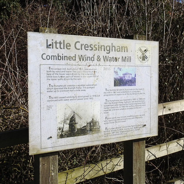
The mill ceased working by wind in 1916 but continued as a water mill until 1952.
The mill has been in the care of the Norfolk Windmills Trust since 1981.
Norfolk has nearly 40 rivers and becks as well as the Norfolk Broads. The primary rivers are the River Waveney which with the River Little Ouse create the boundary between Norfolk and Suffolk. The Yare rises south of Dereham and runs into Breydon Water and discharges into the North Sea at Great Yarmouth. The River Wensum is a tributary of the River Yare, despite being the larger of the two rivers. The River Bure rises near Melton Constable, flows as far as through Runham and Great Yarmouth where it meets Breydon Water and flows into the sea at Gorleston. The River Great Ouse only enters Norfolk at Brandon Creek, Norfolk. The River Tud has its source just south of East Dereham and it flows in an easterly direction for 27 kilometres (17 mi) to its confluence with the Wensum below Hellesdon mill. The River Nar is a tributary of the River Great Ouse. It rises at Mileham in Norfolk and flows 15 miles west through Castle Acre and Narborough (the latter giving the Nar its name), joining the Ouse at King's Lynn. The River Chet at Loddon Marina.
Norfolk has roughly 154 watermills listed as either lost, demolished, partial ruin or extant and converted to another use. Of these, either the mill or the miller's house, are now private houses, B&Bs or the larger ones, multiple occupancy flats.
Watermills were by necessity beside a river or stream with enough flow to turn a waterwheel and the gears inside the mill. There are a number of options for the method in presenting the water to the paddles on the wheel. Undershot is where the bottom of the wheel sits in the flow. Breast shot is where the water is presented to the wheel halfway up and the wheel and doesn't sit in the stream. Overshot is where the water flows over the top of the wheel and is the most powerful of the three methods.
A fourth method not used in Norfolk, is known as a pentrough or pitchback, which is similar to an overshot but turns the wheel in the opposite direction. See Link.
Mills were used to grinding corn, making paper, extracting oil, sawing wood and numerous other jobs which are listed in the above Wikipedia article. created by Adrian Pye
 Map © Crown Copyright")
- Grid Square
- TF8600, 68 images (more nearby 🔍)
- Photographer
- Adrian S Pye (more nearby)
- Date Taken
- Friday, 15 February, 2019 (more nearby)
- Submitted
- Wednesday, 4 August, 2021
- Subject Location
-
OSGB36:
 TF 8697 0021 [10m precision]
WGS84: 52:34.0546N 0:45.4374E - Camera Location
-
OSGB36: TF 8696 0019
- View Direction
- North-northeast (about 22 degrees)