SZ0387 : Sandbanks Ferry, near Poole
taken 3 years ago, near to Sandbanks, Bournemouth, Christchurch & Poole, England
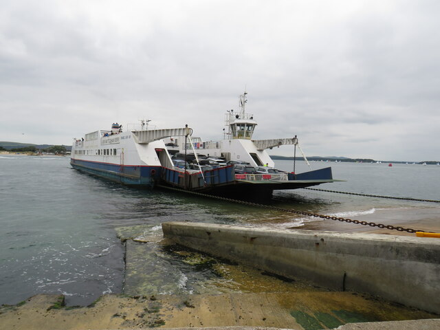
Sandbanks Ferry is a vehicular chain ferry which crosses the entrance of Poole Harbour in Dorset. The route runs from Sandbanks to Studland and in doing so connects the coastal parts of the towns of Bournemouth and Poole with Swanage and the Isle of Purbeck. This avoids a 25 mile journey by road on a return trip.
The ferry, along with the road that connects with it on the Studland side, is owned by the Bournemouth - Swanage Motor Road and Ferry Company, which initiated the ferry crossing in 1923, and a toll is charged for use of both road and ferry. The current toll for a car is £3.50 each way. The current ferry boat, named Bramble Bush Bay, was put into service in 1994 and can carry up to 48 cars. It is the fourth vessel to operate on the route.
The entrance to Poole Harbour is a particularly busy waterway, used by many private and leisure craft along with commercial vessels including large ferries serving routes to France. This often affects the ability of the ferry to maintain its nominal 20 minute frequency. Buses cross the ferry frequently throughout the day, on route 50 from Bournemouth to Swanage.
Wikipedia: Link
Website: Link
National Route 2 will link Dover with St. Austell when complete via the south coast of England and is sometimes referred to as the South Coast Cycle Route.
The route is only fully open, at present, and signed between Dover and Brighton, but is still under development between Brighton and St. Austell.
The National Cycle Network is a network of cycle routes. It was created by the charity Sustrans Link
Many routes aim to minimise contact with motor traffic, though 70% of them are on roads. In some cases the NCN uses pedestrian routes, disused railways, minor roads, canal towpaths, or traffic-calmed routes in towns and cities.
 Map © Crown Copyright")
- Grid Square
- SZ0387, 462 images (more nearby 🔍)
- Photographer
- Malc McDonald (more nearby)
- Date Taken
- Monday, 23 August, 2021 (more nearby)
- Submitted
- Thursday, 2 September, 2021
- Subject Location
-
OSGB36:
 SZ 0371 8703 [10m precision]
WGS84: 50:40.9749N 1:56.9310W - Camera Location
-
OSGB36: SZ 0373 8705
- View Direction
- Southwest (about 225 degrees)