SD7586 : Cowgill chapel - south side
taken 3 years ago, near to Cowgill, Cumbria, England
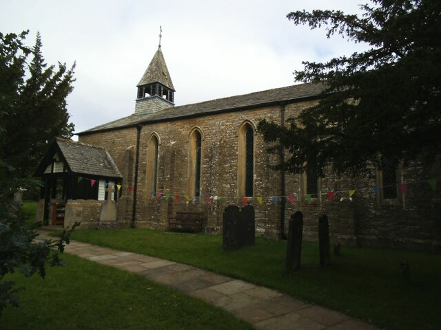
The church was built in 183738, and has previously been known as Kirkthwaite Chapel, and Cowgill Chapel. It was designed by the Lancaster architect Edmund Sharpe. Its design is similar to that of Holy Trinity Church, Howgill, which dates from the same period. The foundation stone was laid on 30 June 1837 by Adam Sedgwick, Professor of Geology at Cambridge University. The church was consecrated on 31 October 1838 by the Bishop of Ripon. It provided seating for 250 people.
St John's is constructed in coursed sandstone rubble with slate roofs. Its architectural style is Early English. The plan consists of a six-bay nave, a single-bay chancel with a vestry to the north, a south porch, and a bellcote at the west end. Each bay contains a lancet window, and the bays are separated by buttresses. On the south side of the church is a wooden gabled porch. The bellcote has wooden louvres, and a steep pyramidal roof surmounted by a weathervane. At the gabled west end of the church is a central buttress flanked by lancets, above which is an oculus. The east window is a stepped triple-lancet. Inside the church are wall memorials to members of the Elam family and others. The single-manual organ was built by T. Hopkins and Son.
Grade II listed. Link
 Map © Crown Copyright")
- Grid Square
- SD7586, 153 images (more nearby 🔍)
- Photographer
- Stephen Craven (more nearby)
- Date Taken
- Friday, 27 August, 2021 (more nearby)
- Submitted
- Monday, 13 September, 2021
- Subject Location
-
OSGB36:
 SD 7560 8694 [10m precision]
WGS84: 54:16.6509N 2:22.5735W - Camera Location
-
OSGB36: SD 7561 8693
- View Direction
- West-northwest (about 292 degrees)