2007
TQ8140 : Weaversden Oast, Biddenden Road, Frittenden, Kent
taken 17 years ago, near to Frittenden, Kent, England
This is 1 of 4 images, with title Weaversden Oast, Biddenden Road, Frittenden, Kent in this square
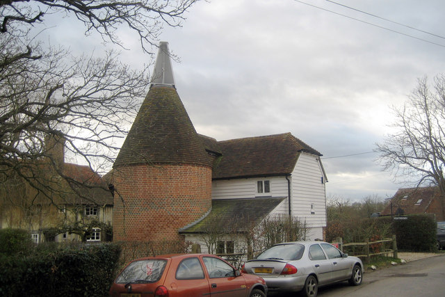
Weaversden Oast, Biddenden Road, Frittenden, Kent
See other images of Listed Oast Houses
Weaversden Oast
Single round kiln oast house. Now used as holiday accommodation.
Grade II listed.
Oast Houses
An Oast House is a building used to dry fresh hops before they are sent to the brewers, to be used for flavouring beer. A traditional Oast House consists of the 'oast' and the 'stowage'. The oast was a kiln, with a plenum chamber fired by charcoal at ground floor and the drying floor directly above. The steep pitched roof channelled the hot air through the hops to the top. The stowage, was the barn section, it had a cooling floor and press at first floor and storage area at ground floor. Read more Link
 Map © Crown Copyright")
TIP: Click the map for more Large scale mapping
- Grid Square
- TQ8140, 121 images (more nearby 🔍)
- Photographer
- Oast House Archive (more nearby)
- Date Taken
- Sunday, 28 January, 2007 (more nearby)
- Submitted
- Friday, 7 March, 2008
- Subject Location
-
OSGB36:
 TQ 8186 4081 [10m precision]
WGS84: 51:8.2606N 0:35.8893E - Camera Location
-
OSGB36: TQ 8190 4086
- View Direction
- Southwest (about 225 degrees)