2022
SJ7994 : Stretford Public Hall
taken 2 years ago, near to Stretford, Trafford, England
This is 1 of 3 images, with title Stretford Public Hall in this square
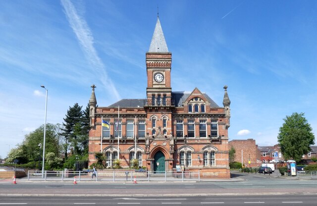
Stretford Public Hall
The Grade II listed building Link was built by the philanthropists John and Enriquetta Rylands in 1878. John Rylands was Manchester's first multi-millionaire, who made his money from textile mills. The Hall was designed by architect N. Lofthouse in a mixed gothic revival style. It was intended to be a public hall, with lecture rooms and the town's first free lending library.
Following John Ryland's death in 1888, his widow Enriqueta rented the building to the local authority. The hall became known as Stretford Town Hall. In 1910, the Hall was bought by Stretford Council for a nominal fee of £5,000. In 1940, the new Stretford Library was opened on King Street and Stretford Public Hall's library was no longer needed, leading to the hall's closure.
The building re-opened in March 1949 as the Stretford Civic Theatre. In December 1977, the theatre secured its place in local music history when it hosted the Rock against Racism Christmas Party, featuring John Cooper Clarke, The Worst and The Fall. However the Hall later fell into disrepair and eventually, Trafford Council refurbished and converted it to serve as council offices in the mid-1990s. It was re-opened in 1997, once again named Stretford Public Hall.
The hall is now run by Friends of Stretford Public Hall, who have owned the building since a community asset transfer in 2015. They are a charitable Community Benefit Society with over 800 members. They provide accessible community space and deliver a programme of events and activities, including arts activities, live music nights, community cinema, and health and wellbeing activities.
Stretford Public Hall website: Link
A Ukrainian flag is currently flying outside.
 Map © Crown Copyright")
TIP: Click the map for more Large scale mapping
- Grid Square
- SJ7994, 137 images (more nearby 🔍)
- Photographer
- Gerald England (more nearby)
- Date Taken
- Saturday, 30 April, 2022 (more nearby)
- Submitted
- Sunday, 8 May, 2022
- Subject Location
-
OSGB36:
 SJ 7971 9445 [10m precision]
WGS84: 53:26.7853N 2:18.4174W - Camera Location
-
OSGB36: SJ 7975 9444
- View Direction
- West-northwest (about 292 degrees)