2023
TG2308 : Serpentine wall near Pulls Ferry
taken 3 years ago, near to Norwich, Norfolk, England
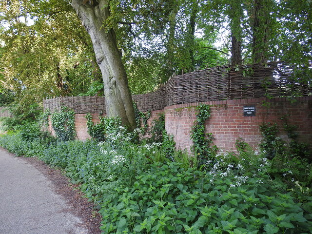
Serpentine wall near Pulls Ferry
A serpentine or crinkle-crankle wall was initially designed to save bricks and reduce to cost of building walls. Suffolk seems to be the historical birthplace of the metamorphic remodelling of the straightforward into the curiously peculiar.
A wavy wall can be built with the thickness of a single brick and is self supporting even in very strong winds whereas a straight wall requires a thickness of at least two bricks (9 inches) and even buttresses if raised over about three feet.
Wikipedia has a few words to add: A crinkle crankle wall, also known as a crinkum crankum, slangenmuur (snake-wall) sinusoidal, serpentine, ribbon or wavy wall, is an unusual type of structural or garden wall built in a serpentine shape with alternating curves, originally used in Ancient Egypt, but also typically found in Suffolk in England. Although they can appear anywhere in the country.
The alternate convex and concave curves in the wall provide stability and help it to resist lateral forces, leading to greater strength than a straight wall of the same thickness of bricks without the need for buttresses.
The phrase "crinkle crankle" is an ablaut reduplication, defined as something with bends and turns, first attested in 1598 (though "crinkle" and "crankle" have somewhat longer histories).
See other images of Crinkle-crankle walls in Norfolk


TIP: Click the map for more Large scale mapping
- Grid Square
- TG2308, 6588 images (more nearby 🔍)
- Photographer
- Adrian S Pye (more nearby)
- Date Taken
- Tuesday, 16 May, 2023 (more nearby)
- Submitted
- Tuesday, 16 May, 2023
- Subject Location
-
OSGB36:
 TG 23878 08741
[1m precision]
WGS84: 52:37.8133N 1:18.4036E - Camera Location
-
OSGB36:
TG 2388 0875
- View Direction
- South-southwest (about 202 degrees)


