2023
SH7342 : Craig y Garreg-lwyd
taken 3 years ago, 3 km from Llan Ffestiniog, Gwynedd, Wales
This is 1 of 3 images, with title Craig y Garreg-lwyd in this square
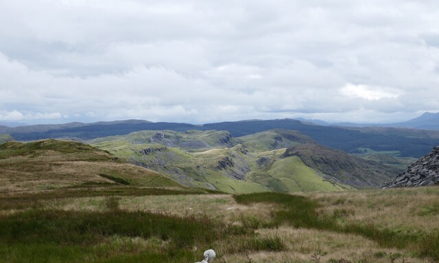
Craig y Garreg-lwyd
Eryri National Park (Snowdonia). View looking south from the Cwt-y-bugail slate quarry on Manod Mawr (661m) to the disused Drum slate quarries located among the rocky outcrops known as Craig y Garreg-lwyd.
In the far distance are: to the left: Rhobell Fawr (734m) of the Arenig range, and to the right: the Cadair Idris range with its peak Penygadair (893m) and very far right on edge of image, Y Garn (629m) at the south eastern extreme of Y Rhinogydd (the Rhinog range).
Philbhu image ref: P1100395ag.
In the far distance are: to the left: Rhobell Fawr (734m) of the Arenig range, and to the right: the Cadair Idris range with its peak Penygadair (893m) and very far right on edge of image, Y Garn (629m) at the south eastern extreme of Y Rhinogydd (the Rhinog range).
Philbhu image ref: P1100395ag.

Eryri :: SH5646
Parc Cenedlaethol Eryri (Eryri National Park) (was formerly known in English as 'Snowdonia' National Park) lies within two counties of Wales (Gwynedd and Conwy) and was created in 1951. Link

Manod Mawr :: SH7244 (provided by Barry Hunter)
The peak is 661 metres above Sea Level. The top features the remains of a Trig Point, which was demolished at some point, leaving only the base.


TIP: Click the map for more Large scale mapping
- Grid Square
- SH7342, 16 images (more nearby 🔍)
- Photographer
- Phil Brandon Hunter (more nearby)
- Date Taken
- Wednesday, 2 August, 2023 (more nearby)
- Submitted
- Sunday, 31 December, 2023
- Subject Location
-
OSGB36:
 SH 732 427
[100m precision]
WGS84: 52:58.0091N 3:53.3053W - Camera Location
-
OSGB36:
SH 734 455
- View Direction
- SOUTH (about 180 degrees)


