2008
TG1943 : Chalk rafts below Wood Hill
taken 16 years ago, near to East Runton, Norfolk, England
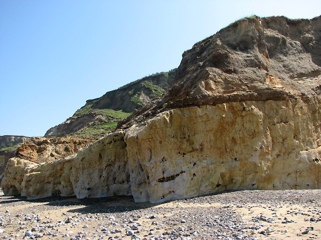
Chalk rafts below Wood Hill
The white chalk rafts seen in the cliff section on the approach to and directly below Wood Hill > Link were shaped by ice, raising up to 40 metres above beach level. The chalk is composed of calcium carbonate from the remains of microscopic marine organisms that once lived in a warm shallow sea which covered this area between 62 and 132 million years ago. Layers of flint pebbles can be seen embedded in the chalk. The layer above is the so-called Cromer Stone Bed, covered by Weybourne Crag, outcrops of which can be seen on the foreshore near East Runton Gap and also by Wood Hill, further to the west > Link. Weybourne Crag dates from about 2 million years ago; it is composed of grey shelly sands that sit on top of a bed of flints, pebbles and shells. Often the crag and stone layers are cemented together by iron pan, giving the deposit a reddish colour. Link (Archive Link )
Link (Archive Link )
Link
 Map © Crown Copyright")
TIP: Click the map for more Large scale mapping
- Grid Square
- TG1943, 63 images (more nearby 🔍)
- Photographer
- Evelyn Simak (more nearby)
- Date Taken
- Wednesday, 7 May, 2008 (more nearby)
- Submitted
- Thursday, 8 May, 2008
- Subject Location
-
OSGB36:
 TG 195 430 [100m precision]
WGS84: 52:56.3723N 1:15.9781E - Camera Location
-
OSGB36: TG 195 430
- View Direction
- South-southeast (about 157 degrees)