2008
TQ4178 : Footbridge with rebuilt parapet, Maryon Park
taken 16 years ago, near to Charlton, Greenwich, England
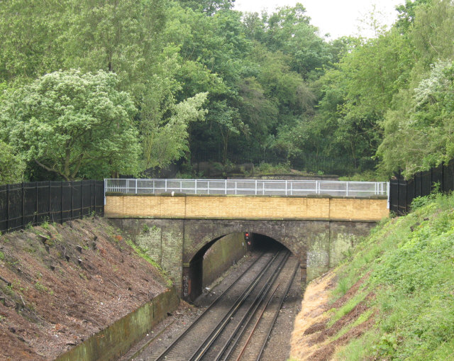
Footbridge with rebuilt parapet, Maryon Park
The footbridge carries the Green Chain Walk over the railway within the park. This view would have been obscured until recently due to the large amount of overhanging vegetation on the sides of the cutting, but it was cleared back when the bridge parapet was rebuilt in 2007 - hence the lighter coloured brickwork.
Green Chain Walk :: TQ4475
The Green Chain Walk is a network of paths in south-east London that connects locations including the Thames Barrier, Thamesmead and Erith along the river, and at the other end Crystal Palace and Chislehurst.
The route was created in 1977 by a joint team of four London boroughs. What makes it distinctive is the way it connects parks and other open spaces as far as possible, including fragments of ancient woodland at Oxleas and Lesnes Abbey Woods, heathland at Plumstead Common and large parks such as Avery Hill and Crystal Palace. The longest continuous route is Thamesmead to Crystal Palace (26.5km), with many links making up the total of 64km.
The official website is Link
 Map © Crown Copyright")
TIP: Click the map for more Large scale mapping
- Grid Square
- TQ4178, 285 images (more nearby 🔍)
- Photographer
- Stephen Craven (more nearby)
- Date Taken
- Tuesday, 27 May, 2008 (more nearby)
- Submitted
- Tuesday, 27 May, 2008
- Subject Location
-
OSGB36:
 TQ 419 788 [100m precision]
WGS84: 51:29.4317N 0:2.5509E - Camera Location
-
OSGB36: TQ 419 788
- View Direction
- Southwest (about 225 degrees)